Download
1 / 18
180 likes | 268 Views
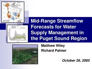
Puget Sound Oceanography: Estuarine Processes. OCN 506C/497C Winter Term 2011 Parker MacCready & Julie Keister http://faculty.washington.edu/pmacc/Est2011/Estuaries2011.html. Class Structure & Expectations. Lectures MWF 11:30-12:20, OSB 425 Also labs and Guest Experts

E N D
Puget Sound Oceanography:Estuarine Processes OCN 506C/497C Winter Term 2011 Parker MacCready & Julie Keister http://faculty.washington.edu/pmacc/Est2011/Estuaries2011.html
Class Structure & Expectations • Lectures MWF 11:30-12:20, OSB 425 • Also labs and Guest Experts • This Wednesday: meet at the Old Ocean Building, ground floor, for the Puget Sound Model • Reading, Discussion, Short Response Essays (1-2 pages) 60% • Final Project – paper (5-10 pages) and presentation 40% • Undergraduates: no final talk? • There is no final exam
You • Please email us with (1) a short description of your oceanography background, and (2) a sentence or two about why you are in the class. • parker@ocean.washington.edu • jkeister@u.washington.edu
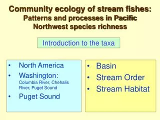
Puget Sound Basins, Sills, Rivers, Stratification, and Mean Currents Getting to know the Sound
Names • Strait of Juan de Fuca • Admiralty Inlet • Main Basin • Whidbey Basin • Port Susan • Tacoma Narrows • Colvos Passage • South Sound • Hood Canal • Lynch Cove
Names • Strait of Juan de Fuca • Admiralty Inlet • Main Basin • Whidbey Basin • Port Susan • Tacoma Narrows • Colvos Passage • South Sound • Hood Canal • Lynch Cove
Names • Strait of Juan de Fuca • Admiralty Inlet • Main Basin • Whidbey Basin • Port Susan • Tacoma Narrows • Colvos Passage • South Sound • Hood Canal • Lynch Cove
Names • Strait of Juan de Fuca • Admiralty Inlet • Main Basin • Whidbey Basin • Port Susan • Tacoma Narrows • Colvos Passage • South Sound • Hood Canal • Lynch Cove
Bathymetry • The Sound is a system of deep basins linked by shallow sills • Glacially carved to 600 m • Filled in by sediment to 200m
Cross-sectional shapes • Steep sidewalls (1:5) • Narrow constrictions Juan de Fuca
Cross-sectional shapes • Steep sidewalls (1:5) • Narrow constrictions
Cross-sectional shapes • Steep sidewalls (1:5) • Narrow constrictions
Watersheds • Skagit and Snohomish have much of their watershed in the Cascade mountain range
Rivers • Data from USGS gauges • High flow period during the winter due to storms (direct rain) • High flow during the spring due to snowmelt (the “spring freshet”) • Biggest rivers flow into Whidbey Basin (Skagit and Snohomish) • Total for Puget Sound averages 1000 m3 s-1 • Average for the Fraser River (Georgia Strait) is 4500 m3 s-1
Stratification • Density is mostly controlled by salinity • Stagnant basins are more stratified, especially near the surface Juan de Fuca Main Basin Whidbey Basin South Sound Hood Canal
Tidally-Averaged Current • The observed along-channel flow is mostly “two layered” • Surface flows out, deep flows in • In and out transport it MUCH greater than that due to the rivers alone!!! Juan de Fuca There is a strong mean northward flow at all depths in Colvos Passage, balancing net southward flow in East Passage (clockwise circulation around Vashon Island) Main Basin South Sound Hood Canal Whidbey Basin
Map • Cokelet et al. (1990)