Download
1 / 22
220 likes | 253 Views
Learn about the history, remedial actions, groundwater investigations, and costs involved in cleaning up the Hooper Sands Road Site in South Berwick, Maine.

E N D
Hooper Sands Road SiteSouth Berwick Brian Beneski Division of Remediation MAINE DEPARTMENT OF ENVIRONMENTAL PROTECTION Protecting Maine’s Air, Land and Water
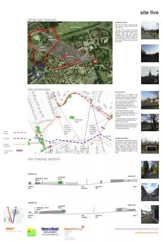
What was the Hooper Sands Road Site? • Consisted of multiple lots comprising several hundred acres on Hooper Sands Road and Knights Pond Road. • Property owner at the time used the property in the 1960s and 1970s to reclaim and dispose of waste oils and other chemicals generated at the Portsmouth Naval Shipyard and other industrial concerns.
What was the Hooper Sands Road Site • Six source areas: • 1 – Knights Pond Road Above Ground Tank area • 2- Northern Drum Storage Area • 3- Southern Drum Storage Area • 4 - Septic Spreading Area • 5 - Hussey Gravel Pit Above Ground Tank area • 6 – Main Disposal Trench Area Available “Status Report” dated 1996, provides a detailed description of the sources and remedial activities at each source.
Site History • Initial Discovery – 1989 • January – the DEP contacted by resident regarding gasoline smell in groundwater, DEP sampling ensued • February - Initial treatment systems installed on impacted residential wells • June – Submitted preliminary assessment to USEPA as a potential site for the National Priorities List, aka “Superfund”
Remedial actions conducted from 1989 - 1992 Fall 1989 – Began a series of removal actions by USEPA’s Emergency Response Branch and the DEP 3,000 cubic yards of contaminated soil from sources areas #2, #3, #4 and staged for treatment/disposal Staging of drums and other containers Summer 1990 – Removal of several hundred drums and other containers December 1990 – on site treatment of staged soil Summer 1991 – additional drum/waste oil consolidation and staging November 1992 – Completion of the removal of all waste oil consolidated from on site tanks and containers. Removal Actions MAINE DEPARTMENT OF ENVIRONMENTAL PROTECTION www.maine.gov/dep
Groundwater Investigation • Groundwater investigation conducted in stages, completed in August 1990 and December 1991. • Department continued monitoring residential well filter systems until water line installation in 1994 • Department continued monitoring general groundwater conditions via monitoring wells installed during groundwater investigation until 1999.
Water Line Installation • September 1993 - Waterline contract signed between South Berwick WD and DEP • June 1994 – Waterline Construction began • November 7, 1994 – First residents connected • December 22, 1994 – Waterline connections completed
Final Activities • November 1995 – additional sampling activities at Gravel pit location (no contamination detected) • August 1996 – USEPA determines site will not score for the National Priorities List • 1999 – DEP ends groundwater monitoring • 2011 – DEP closes out groundwater monitoring wells
Costs • Investigations and Removal Actions: • USEPA – $2,025,000 • DEP – $1,400,000 • Water Line: • USEPA – $563,000 • DEP - $492,000 • South Berwick Water District – $140,000
Hooper Sands Road SiteSouth Berwick Troy Smith Hydrogeology Unit Manager Maine Certified Geologist MAINE DEPARTMENT OF ENVIRONMENTAL PROTECTION Protecting Maine’s Air, Land and Water
Hydrogeologic Investigations • Weston Geophysical Corporation completed a two-stages of investigation in 1990 and 1991 • Investigated the 6 Source Areas • Completed Soil and Bedrock Borings • Installed Monitoring Wells in soils and bedrock • Sampled Private water supply wells
Summary of Hydrogeology • The area is underlain by a mapped Significant Sand and Gravel Aquifer • Beneath the Sand and Gravel aquifer there is a discontinuous layer of glacial till • The bedrock surface is located between 8 and 120-feet below the ground surface across the 6 parcel area
Groundwater Contamination • Contamination is present in the Sand and Gravel and in the bedrock • Bedrock contamination was detected in 5 bedrock water supply wells during the 1990 and 1991 investigations • Contaminants included several Volatile Organic Compounds (VOCs)
Decision to Extend Water Line • PCE and TCE are present in several monitoring wells and bedrock water supply wells across the area of investigation • Complex hydrogeologic setting: • groundwater flow patterns showing groundwater flowing east, west, and south • Contamination in 120-foot thick overburden • Contamination present in fractured bedrock
Decision to Extend Water Line • Remediation of the plume is very difficult to achieve because of the low drinking water criteria (3-5 ug/L in 1991) • Removal of 99% of the contamination in the aquifer would still leave groundwater concentrations that are above the drinking water criteria • Achieving the drinking water criteria in this setting is not practical or realistic
Water Line Extension • The decision to extend the water line was a valid risk-based decision in the 1990’s and it is still a valid decision in 2019 • The complex Hydrogeologic Setting encountered at the Hooper Sands Road Site makes aquifer restoration and remediation of the groundwater plume technically impracticable
Plan Going Forward • Implement a plan to utilize the existing water line • Sample existing water supply wells within the study area, starting with wells on or adjacent to the 6-parcels and working outward • Provide definitive documentation & notification of gw contamination to avoid wells installed in the plume.