Download
1 / 27
280 likes | 314 Views
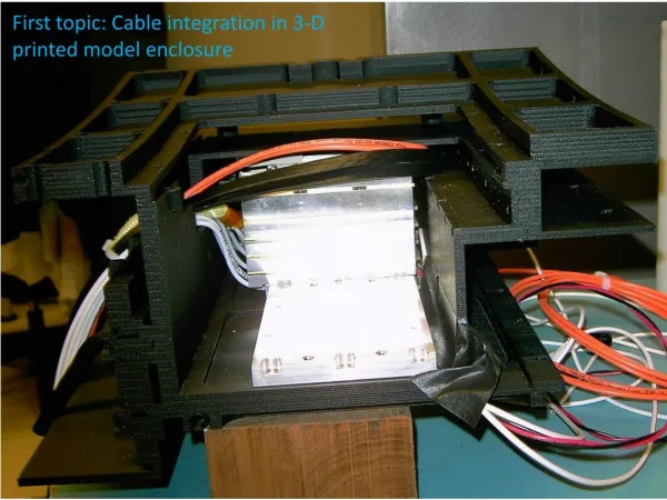
This project showcases how a regional 3D printed population model was developed using GIS technologies for the Hyperloop One Global Challenge. The model, created by Jason Kaper, a GIS Specialist from the Mid-Ohio Regional Planning Commission, and Matt Organiscak, Vice President of IC3D Industries, was presented at the Ohio GIS Conference in September 2017. The proposal aimed to demonstrate the feasibility of utilizing 3D printing technology to represent population data in a unique and innovative way. The process involved converting population data into a three-dimensional format, which was then exported for printing using specific software and techniques. The presentation covered the entire process from data collection to the final 3D print output, offering insights into the potential applications of this method for urban planning and transportation projects.

E N D
Creating a Regional 3-D Printed Population Model for the Hyperloop One Global Challenge Jason Kaper GIS Specialist Mid-Ohio Regional Planning Commission Matt Organiscak Vice President IC3D Industries Ohio GIS Conference September 25 – 27, 2017 Hyatt Regency Columbus Columbus, Ohio
Regional Proposal for Hyperloop One Global Challenge Delegation to Washington DC April 4, 2017
We want this: For this: Population of Europe/SavvasKarmaniolas
IC3D Industries Meshlab ArcMap ArcScene Population Data to TIN Elevate TIN into 3D Conversion into useable file for printer Print
http://sedac.ciesin.columbia.edu/ Comprehensive Small Geography Easy 800,000 cells for the five states max (Phila.): 17,000 Central Ohio max (Oh. St. Campus): 7500 Global 2015 population into 30 arc-second grids (Approximately 1km)
ArcMap (3D Analyst) Raster to TIN SEDAC raster Z Tolerance: The maximum allowable difference between the height of the input raster and the height of the output TIN. Population values are carried over from the raster.
ArcMap (3D Analyst) Edit TIN Triangulated Irregular Network SF Type: Polygon surface types have Hard and Soft qualifiers that indicate whether the features represent smooth or sharp discontinuities in slope along the surface. This tool does not produce an output separate from the input TIN. This will (as the name implies) edit the TIN!
ArcScene Setting Base Height
ArcScene Vertical Exaggeration (if necessary)
ArcScene Export VRML (.wrl extension)
MeshLab Open source system for processing and editing 3D triangular meshes.
MeshLab Scale down 3D mesh
SEDAC dataset raster ArcMap ArcMap ArcScene MeshLab TIN Raster to TIN Edit TIN Set Base Height Rescale Export Export .wrl .stl
3D Printing Technology 101 • Material Extrusion (FDM) • Vat Photopolymerization (SLA) • Material Jetting • Powder Bed Fusion • Binder Jetting • Sheet Lamination
Material Extrusion Images from 3D Hubs & E-nable
Vat Photopolymerization Images from 3D Hubs
Material Jetting Images from 3D Hubs
Powder Bed Fusion Images from 3D Hubs & GE & Koenigsegg
Binder Jetting Images from 3D Hubs
Sheet Lamination Images from 3D Hubs & Mcor
IC3D Print Process • Receive Files (.stl) • Programming and Checks • Slicing Software – Simplify 3D • Mesh Cleanup • Software – Netfabb or MeshMixer • Final Programming • Set Up and Print
Jason Kaper jkaper@morpc.org Matt Organiscak matt@ic3dprinters.com