Download
1 / 21
220 likes | 397 Views
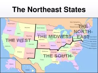
Drought Management Strategies and Indices of Northeast Coastal Plain States. Andrew Benjamin University of Delaware. Goals: To investigate Drought Monitoring plans of states along the coastal plain.

E N D
Drought Management Strategies and Indices of Northeast Coastal Plain States Andrew Benjamin University of Delaware
Goals: • To investigate Drought Monitoring plans of states along the coastal plain. • Review literature and identify drought indices that could be used to monitor drought operationally in Delaware.
Delaware • Delaware Drought Index (1982) • Adopted by Delaware Drought Committee • Based on 6 month precipitation and average monthly stream flow. • One indicators is deficient= semi-deficient month. • Both are deficient= deficient month.
Delaware • Drought Conditions • Drought Warning- induced by two consecutive deficient months. • Drought (Drought Emergency)- induced by four consecutive months.
Delaware • A Numerical Indicator of Water Conditions for Northern Delaware ( Jordan and Woodruff, 1982) • Water Conditions Index • Compared to the PDSI, the above index is less sensitive to short-term changes in precipitation. • Not dependent on soil moisture values.
New Jersey • New Jersey Department of Environmental Protection • New Jersey Drought Emergency Plan (1991) • Divided in to 6 drought regions • 4 Drought Indicators • Precipitation, Streamflow, Groundwater, Resovoirs • Updated weekly under dry conditions, biweekly under normal/wet conditions.
Maryland • 1.) Drought Monitoring Response Plan (2000) • Army Corps of Engineers’ definition of drought: “Droughts are periods of time when natural or managed water systems do not provide enough water to meet established human and environmental uses because of natural shortfalls in precipitation or stream flow.”
Maryland • Divided into 6 regions (based on county lines). • 4 Drought indicators • Precipitation, Streamflow, Groundwater, Reservoir storage • Palmer Drought Severity Index • Not used specifically for drought management. • Used to observe long term trends of water supplies in aquifers, reservoirs, and streams.
Maryland • Susquehanna River Basin Drought Coordination Plan (2000) • Palmer Drought Severity Index • Drought Watch: -2.00 to -2.99 • Drought Warning: -3.00 to -3.99 • Drought Emergency: -4.00 and greater
Pennsylvania • Pennsylvania State Water Plan • Indicators • Precipitation, streamflow, groundwater, soil moisture, and reservoir levels. • Member of the Susquehanna River Basin Commission
New York • Drought Hazard Profile • Defines and highlights potential impacts of Hydrologic and Agricultural drought • Economic, Environmental and Social factors. • New York State Drought Plan (1982; revised 1988) • Monitored Monthly • Climatological data, reservoir/lake storage, stream flow and groundwater levels • Palmer Drought Index and State Drought Index Used • Stages of Drought • Normal, Drought Alert, Drought Warning, Drought Emergency, Drought Disaster
Virginia • Drought Assessment and Response Plan (2003) • Drought Response Technical Advisory Committee • Drought Indicators • Precipitation, stream flow, groundwater, reservoir storage • Indicators compared to percentiles from historical data.
North Carolina • Drought Assessment and Response Plan (2003) • More response plan then detection plan • Stages • Normal, Normal-Dry, Moderate Drought, Severe Drought, Extreme Drought
Coastal Carolinas • Regional Drought Early Warning Systems • “Currently, pilot project steering committees are working to refine the project plans and engage potential partners.”
Summary • States that utilize drought indices as well as monitor drought indicators: • Delaware • Maryland • New York • States that only monitor drought indicators against historical averages: • Pennsylvania • New Jersey • Virginia
Operational Indices in Literature • Zarger, et al, 2011 • PDSI- Palmer Drought Severity Index • SPI- Standardized Precipitation Index • NDVI- Normalized Difference Vegetation Index • U.S Drought Monitor (USDM) • Deciles- dividing long periods of precipitation data into 10% parts
Operational Indices in Literature • Brown et. al, 2008 • Vegetation Drought Response Index (VegDRI)- combines NDVI, SPI and PDSI • Can provide near-real time maps of drought severity • Better Resolution than USDM- useful for local planning and mitigation
Operational Indices in Literature • Rhee, Im, and Carbone, 2010 • Scaled Drought Condition Index (SDCI) • Combines NDVI, LST data, and precipitation data(TRMM) • Highly correlated with PDS, SPI and outperformed Vegetation Health Index (VHI) and NDVI in North and South Carolina.
References • Brown, J.F., Wardlow, B.D., Tadesse, T., Hayes, M.J., and Reed, B.C., 2008. The Vegetation Drought Response Index (VegDRI): A new integrated approach for monitoring drought stress in vegetation. GIScienceand Remote Sensing, 45 (1): 16–46. • Heim, R. R., 2002. A Review of twentieth-century drought indices used in the United States. Bulletin of the American Meteorological Society, 83 (8): 1146-1165. • Rhee, J., Im, J., Carbone, G. J., 2010. Monitoring agricultural drought for arid and humid regions using multi-sensor remote sensing data. Remote Sensing of Environment, 114 (12): 2875-2887. • Zarger, A., Sadiq, R., Bahman, N., and Khan, F.I., 2011. A review of drought indices. Environmental Review. 19: 333-349.