Download
1 / 34
350 likes | 413 Views
Explore the concepts of human territoriality, sovereignty, and territorial morphology in geography. Learn about different state shapes, boundary types, and boundary disputes that impact global affairs.

E N D
Territorial Morphology Human Geography Mrs. Vazquez
What is human territoriality? • Human territoriality is the attempt to control what goes on in a specific geographic area • A country’s sense of property and attachment toward its territory, expressed by its determination to keep it inviolable and defended
What does sovereignty mean? • Sovereignty is the final authority over a territory’s political and military affairs. • Authority to rule
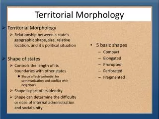
Territorial morphology refers to… • Territorial morphology refers to the size, shape and relative location of a state (country) • This affects the potential for communications and conflict with neighbors • Morphology means “the form and structure of an organism or one of its parts”
Territorial Morphology(shape)5 basic shapes: • Compact (Uruguay, Zimbabwe, Poland) • Prorupt-Protruded (extension out) usually for access to river or ocean Thailand,Myanmar, Namibia, India(not the usual poster boy) • Elongated (Chile) Vietnam • Fragmented (difficult to defend; Philippines, Indonesia, Sweden • Perforated (country that surrounds another) South Africa
Compact States • Distance to center to any boundary does not vary significantly. • Ideally, a circle • Beneficial for most smaller states because communication is easier • Just as likely to experience civil war and ethnic conflict • Belgium • Easier to defend than states of other shapes. • Examples: Poland, Kenya Sierra Leone Rwanda Burundi Swaziland Lesotho
Fragmented States • Includes several discontinuous pieces of territory • 1)fragmented by water (Fiji, Indonesia) • 2)fragmented by other states • Russia (Kaliningrad), US (Alaska) Seychelles Cape Verde Islands Equatorial Guinea and Sao Tome and Principe
Elongated States • States with a long and narrow shape • Suffer from poor internal communications • Isolation of one region from capital • Examples: Italy, Chile, Malawi Togo Malawi
Protruded/Prorupt States • Otherwise compact state • with a large projecting • extension • Created for access to • a resource, such as water • Or, created for separation • of two states that would • otherwise share a boundary • The projecting territory of • Democratic Republic of Congo was made by the Belgians to give the state, then a colony of Belgium, access to the Atlantic Ocean Example: Democratic Republic of Congo, Thailand Somalia Zaire
Perforated States • A state that completely surrounds another state • South Africa/Lesotho South Africa
B E A D C
Boundaries… • a vertical plane that cuts through the subsoil & airspace (even outer space) • transcend soil, water, air • mark the limits of state jurisdiction
Boundaries • differ in morphological terms • Geometric: straight line boundaries • physical-political or natural-political: rivers or mountains • Cultural: political-ethnically based
Boundary Types 1. Physical: mountains, rivers, lakes Rio Grande US /Mexico Pyrenees Mountains bw/ Spain and France Other examples? • Geometric: lines of latitude/longitude North Korea and South Korea -38th parallel .
3. Cultural: separated by language/religion • India & Pakistan
Boundary Origins 1. Antecedent: border before populated boundary that was created before the present day cultural landscape developed Ex: U.S. 2. Subsequent: border drawn after 2 types: • Consequent (Ireland & N. Ireland) • Superimposed (British India, Africa after the scramble)
Consequent • Ireland & N. Ireland
3. Relict/relic Boundary: historical boundary, no longer valid. Great wall of China, Berlin Wall
Boundaries • are often a source of dispute
Boundaries • are defined, delimited, and then demarcated • Defined:legal document drawn up • Delimited:boundary put on a map • Demarcated:boundary marked on the ground
Types of Boundary Disputes 1. Locational: over border 2. Functional/operational: over policies (immigration) • Resource /Allocational Over oil or natural gas 4.Territorial - irredentism
Definitional Boundary Disputes • legal language in dispute
Locational Boundary Disputes • interpretation in dispute
Operational Boundary Disputes • functions of boundary in dispute
Allocational Boundary Disputes • dispute over resources
Exclave and Enclave • Small outliers of territory which are separated from the rest of the territory by another state • The separated territory is referred to as an exclave of the country it is associated with • If the piece of territory lies within another country, it is known as an enclave of the surrounding country