Download
1 / 10
100 likes | 292 Views
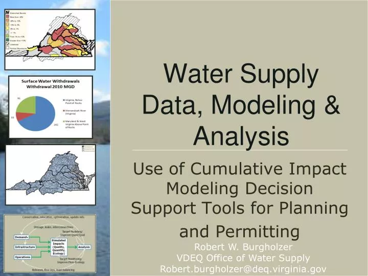
Water Supply Data, Modeling & Analysis. Use of Cumulative Impact Modeling Decision Support Tools for Planning and Permitting. Robert W. Burgholzer VDEQ Office of Water Supply Robert.burgholzer@deq.virginia.gov. Properties of a Decision Support System.

E N D
Water Supply Data, Modeling & Analysis Use of Cumulative Impact Modeling Decision Support Tools for Planning and Permitting Robert W. BurgholzerVDEQ Office of Water Supply Robert.burgholzer@deq.virginia.gov
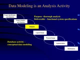
Properties of a Decision Support System • DSS’s Provide a Means of Organizing & Analyzing Information Gather & Organize Information Simulation of Management Actions (models) Data Visualization & Analysis
Function & Info Flow in WSP-DSS Conservation, relocation, optimization, update info Storage, leaks, interconnections Target Modeling/Improve Quan/Qual Demands Simulated Impacts (Quality, Quantity, Ecology) Infrastructure Analysis Operations Target Monitoring/Improve Flow-Ecology Releases, flow-bys, load-balancing
DSS Key Concepts/Functions • Data Acquisition / Electronic • Collaborative Analysis Tools Data Acquisition / Human
Content Management System (CMS) as DSS • Web-Based CMS’s are Built to: • Aggregate Multi-User Content • Manage User Access • Promote Collaboration • Organize Information • Data is Content • Blogs, Video, Social Media harder than #’s • Don’t Reinvent the Wheel (Re-engineer it) • Geo-Spatial CMS (GeoCMS) Adds • Spatial Analysis • Spatial Linking of data (GeoSpatial Hyperlink) • Geographic Info as Organizational Tool
DSS Overview:Virginia Decadal Trends in Water Demand 2010-2040 Location New Demand 2010-2040 Changes in August Low Flow Individual System Demands & Capacity 2010-2040
Geo-Spatial Hyper-linking: Large Watershed Decadal Trends in Water Demand 2010-2040 Location New Demand 2010-2040 Changes in August Low Flow Individual System Demands & Capacity 2010-2040
Geo-Spatial Hyper-linking: Small Watershed Decadal Trends in Water Demand 2010-2040 Location New Demand 2010-2040 Changes in August Low Flow Individual System Demands & Capacity 2010-2040
Built to Integrate and Evolve • Drupal is a Highly Configurable Content Management System • Modularity, support, and robust framework • Coupling – many tools for data export/import • Modules Used: Views, Feeds, Charts, GeoField • Easily Integrated with VAHydro Modeling system
Conclusions • Decision Support is 90% Organization / 10% Inspiration • Sweat the details • Analysis is easy if the organization is solid • Why CMS: Collaboration is Key • Data Sharing IS QA • More Eyes = More Ideas • CMS’s Are Best of Breed Tools for Sharing/Collaboration • Why Web-Based GeoCMS’s are Needed: • Data is Content • GeoCMS’s bridge skill gap