Download
1 / 41
410 likes | 620 Views
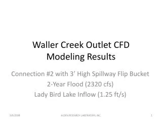
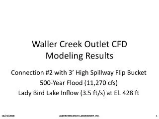
Waller Creek Sub-basin. HMS. Review. Original project idea scrapped Difficult to find adequate GIS data No measured flow data to validate model results Selected new study area. New Area. Area Characteristics. Located on UT campus at 24 th and San Jacinto

E N D
Review • Original project idea scrapped • Difficult to find adequate GIS data • No measured flow data to validate model results • Selected new study area
Area Characteristics • Located on UT campus at 24th and San Jacinto • Dr. Barrett has a monitoring point at basin outlet • Very urban and hydrologically restricted
Goals • Create terrain model in Arcview • Process terrain model with HEC-geoHMS • Create working hydrologic model in HEC-HMS • Calibrate model and evaluate results with measured rainfall and runoff data
Data • TIN developed by Esteban Azagra • One-meter DEM (courtesy of Becky) • Vegetation • Vegetation Removed • Dr. Barrett’s rainfall and runoff data at outlet
Interesting Questions • Which data source is best suited for this application? • How can we use HEC-geoHMS? • How can we create a hydrologic model of a restricted basin in a meaningful way? • How will this model interact with other models created in the area?
Story Begins • It all started with Esteban Azagra’s TIN • Converted TIN to a grid • Projected grid from State Plane to UTM • Overlayed grid onto a DOQQ for position verification
TIN GRID (DEM) Conversion
Projected Grid • Arc-Info
Projected Grid • Code
Story Progresses • Fun with HEC-geoHMS • Familiar with HEC-geoHMS • Processed terrain data • Analyzed final result
Fill Sinks Flow Direction HEC-geoHMS In Action!
Flow Accumulation Watershed Delineation HEC-geoHMS In Action!
End Result: Streams! Cool, but bad! Why? Streams are not behaving No way to modify! HEC-geoHMS In Action!
Drew in sewer system Burned into grid Pre-Pro In Action!
The Plot Thickens! • Becky provides one-meter DEM of study area (E00 Files) • E00 files no longer a mystery to me • Import 71 • Becky solves vegetation problems
Vegetated Vegetation Removed Enter LIDAR!
LIDAR Flow Direction TIN Flow Direction Processing Both Grids in Pre-pro
TIN GIS Model TIN Schematic Creation of HMS Schematic
LIDAR GIS Model LIDAR Schematic Creation of HMS Schematic
The Winner Is: • LIDAR for HMS • Too cumbersome to do both (out of time) • LIDAR looks better • Checked soil types via SSURGO • Developed curve numbers • Input hydrologic attributes • Ran model
Intro to HMS • 3 Parts
Basin Model • Chose SCS for loss and transform methods • Chose no baseflow • Chose lag method for reach routing • Parameters by Hand (and Arcview)
All for this? Soil type is Ur (urban) Either C or D Land use is urban Curve numbers are either 94 (C) or 95 (D) I went with 95 Getting Soiled With SSURGO
Hydrologic Parameters • Sub-basin attributes • Notice SLOPES!! • Those darned buildings!!!
Hydrologic Parameters By Hand (and Arcview) • Reach Attributes • Chose lag transform • Easy
User Specified Hyetograph From 0:00 to 23:55 10/18/99 5 minute increments Meteorologic Model and Control Specifications
After all of this hard work: I am ready to reap what I have sowed RESULTS!!!
But I’m off by a factor of 10 Units problem? Variability in rainfall? Another problem? ??? Looks good …
Calibrate this model (determine problem) Try to use HEC-geoHMS in combination with Pre-pro (burn sewers, process with geoHMS) Figure out how to make Pre-pro transfer hydrologic attributes Study how this model fits into models already completed I Would Like To: