Download
1 / 15
150 likes | 168 Views
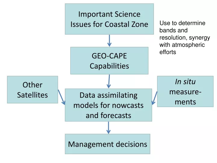
Important Science Issues for Coastal Zone. Use to determine bands and resolution, synergy with atmospheric efforts. GEO-CAPE Capabilities. Other Satellites. In situ measure-ments. Data assimilating models for nowcasts and forecasts. Management decisions. The case for GEO-CAPE.

E N D
Important Science Issues for Coastal Zone Use to determine bands and resolution, synergy with atmospheric efforts GEO-CAPE Capabilities Other Satellites In situ measure-ments Data assimilating models for nowcasts and forecasts Management decisions
The case for GEO-CAPE • Short time scales associated with dynamic coastal processes (tides, wind-driven currents, storm surges, algal blooms) • More opportunities for cloud-free viewing • High signal-to-noise at better spatial resolution (~300m) can be achieved by longer integration time • Opportunity to monitor hazardous events on high frequency time scales
How are human activities influencing: • Harmful algae blooms • Freq, locations, species • Water clarity/quality • Eutrophication • Hypoxia • Acidification • Stratification / precipitation • Fresh water / River inputs • Atmospheric deposition • Living marine resources
Ecosystem based management • Impact of fish harvesting • Climate change • Global warming • Sea-level rise
Harmful algae blooms • Questions: • What is the dynamic of an algae bloom event? • How long? • What effect on water quality? • How do you reduce the risk? • Link to nutrient criteria ? • Science objective: • Measure frequency and intensity of blooms • Understand what causes/maintains/dissipates them • Determine if there is a trend • Measurement: • Ocean spectral reflectance used to derive: • inherent optical properties • CDOM, TSM • Chlorophyll • Phytoplankton taxonomic group / Pigment • Productivity • Measurement requirement: • Temporal: hourly for event / 3 hours systematic • Spatial: 100m (goal IGOS) 500m (threshold) • Spectral: MERIS + UV (360, 380nm) + SWIR (1240, 1550nm) • SNR: • Supporting measurements:
Integration with in situ data and models • Observations made several times per day, together with ancillary information and models, will be used to quantify the pools and pathways of carbon in the coastal ocean. • IOOS • Coastal Ocean Models • Land-ocean models
Synergies with satellites measurements that enable enhanced science • LEO ocean color imager • ACE • Sentinel-3 • High spatial/spectral resolution coastal imaging • HyspIRI • LDCM • Physical • Scatterometry (getting closer to the coastline, rivers) • Altimetry
Geostationary: the only satellite-based method to discriminate physical from biological forcing in the surface ocean Physical forcings: • Tides have a major effect on observed variability: lateral displacement vertical mixing and resuspension sinking • Horizontal eddy diffusion processes • Winds Biological forcings: • Diurnal cycles in cell division and fluorescence • Diurnal cycles in grazing
prod – loss + horizontal + vertical Geostationary: high temporal resolution (hourly) enables coherent observations of rates of change Derived variables (e.g., carbon species): • POC: phytoplankton biomass and detritus • PIC: calcite, inorganic sediment • DOC: region-specific relationship with CDOM • DIC: surface ocean pCO2, carbonate and bicarbonate
Spatial resolution (250 m) is important.. • Size of phytoplankton patches is related to physical dispersion rates and growth rates in coastal waters … growth must counteract physical dispersion for patches to exist (e.g. Harmful Algal Bloom patches). • 250-meter size is ideal -- get info at scale of estuaries and upwelling “hot spots” near coast • Observations of rainfall, land-cover/land-use changes, and effects on coastal ocean (air and water – including ground water)
Fluxes and Pools of Carbon • Objective: To quantify the fluxes and pools of carbon in the coastal ocean. • Measurement Requirement: To quantify and integrate the components of coastal carbon cycle e.g., biomass, primary production, DOC, air-sea flux of CO2. Chlorophyll determination within 30%; primary production estimate order 50%. • Instrument: Ocean color sensor. • Channels • GSD • Frequency of sampling • Platform requirements:
Diverse Environments • Objective: Characterize diverse, optically active water column, benthic and atmospheric constituents. • Measurement Requirement: Minimum spectral sample 10nm, baseline of 5nm. Spectral window (350-1050nm). Lw ~ 1 E-4 W/m^2/sr/nm [CASE II chl=0.05mg/m^3: aCDOM=0.2/m] • Instrument requirement: Hyperspectral imager. SNR 500 at TOA. Polarization sensitivity < 2%; Calibration accuracy 1% (relative); 4% (absolute) • Mission requirement: New algorithms for functional components
Temporal Variability • Objective: Resolve short term temporal variability, mitigate tidal aliasing and cloud cover, and detect episodic events. • Measurement Requirements: Minimum number of synoptic looks (entire U.S. coast) per day 4, baseline of 6. Local/regional capabilities 10 looks/day. • Instrument: Scan 200km along track (east-west) in less than 10 minutes • Platform: Geostationary orbit. Science-driven observing scenario including synoptic and regional experiments.
Spatial Resolution and Coverage • Objective: Resolve small-scale spatial variability in U.S. coastal waters. • Physical variability • Biological variability • Science Measurement Requirement: Minimum ground resolution 1000m, baseline < 500m. Minimum coverage 200km offshore, baseline of 400km. • Instrument requirement: IFOV < 5 arc second. • Mission Requirement: Position at 100°W. Pointing: knowledge < 3 arcsec, accuracy 100 arc sec, stability 0.5 arcsec/sec
Land-Ocean Interface • Objective: Measure properties of adjacent land and their interaction with the coastal ocean. • Science Measurement Requirement: Minimum spectral sample 10nm, baseline of 5nm. Spectral window (450-1050nm). L ~ 100 to1000 brighter than Lw. • Instrument Requirement: Hyperspectral imager. Variable integration time so both land and oceans can be imaged optimally. SNR 200. • Mission Requirements: Science-driven observing scenario to sample adjacent land at lower frequency. Inversion based algorithms to retrieve continental water types.