Download
1 / 23
230 likes | 424 Views
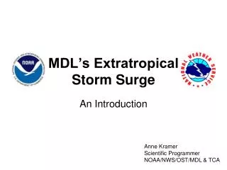
Overview of the Extratropical Surge and Tide Operational Forecast System (ESTOFS) Atlantic. Yuji Funakoshi, Jesse Feyen , and Frank Aikman III (NOS/OCS/CSDL) Andre van der Westhuysen and Hendrik Tolman (NWS/NCEP/EMC). Outline.

E N D
Overview of the Extratropical Surge and Tide Operational Forecast System (ESTOFS) Atlantic Yuji Funakoshi, Jesse Feyen, and Frank Aikman III (NOS/OCS/CSDL) Andre van derWesthuysen and HendrikTolman (NWS/NCEP/EMC)
Outline • The Extratropical Surge and Tide Operational Forecast System (ESTOFS) • ESTOFS Grid • Operational Set-up • ESTOFS Output • Skill Assessment • ESTOFS plans
ESTOFS Overview • Purpose • Provide surge+tide boundary conditions for NCEP/EMC’s Nearshore Wave Prediction System (NWPS) • NWPS predicts coastal wave conditions using SWAN or WAVEWATCH III® coupled to ADCIRC • Provide a second operational set of forecast guidance for extratropical* storms • Leverages community-based storm surge model ADCIRC *Note: cannot accurately model tropical cyclone surge events due to insufficient resolution
Configuration of ESTOFS Atlantic v1.0 • Current configuration • Covers Western North Atlantic, Gulf of Mexico, and Caribbean Sea • Low cost, efficient grid with 3 km to 5 km coastal resolution • Includes astronomical tides • Outputs modeled tides instead of matching observed harmonics at water level stations • Future advancements • Improve coastal resolution of estuaries, rivers, inlets, and barrier islands • Connect to river models • Apply to Pacific and Alaska regions
ESTOFS Grid • ADCIRC East Coast tidal database grid (EC2001) • 254,565 nodes • Coastal resolution ≈ 3 km • Specifies the tidal boundary forcing at 60o W
Operational Set-up • 4 times per day run cycle alongside the GFS model • Time is 00z, 06z, 12z, and 18z • Total 7.75 days simulation • 6-hr nowcast followed by 180-hr forecast • Surface forcing from GFS • 10 m winds and sea level pressure every 3 hours • ESTOFS runs alongside GFS • Tidal forcing from TPXO v6.2 global tide model
Operational Set-up • In 30 day parallel testing on NCEP’s CCS • Evaluation period began April 24th at 1200 UTC and will run through May 24th • Aimed implementation for June 5 or 12 • App. 120 mins wall clock time for one cycle • 1 CCS node with 64 Logical CPUs • Will be available in AWIPS II in FY13 • OSIP 10-019 in process
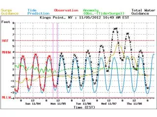
ESTOFS Output • Delivers three types of water level relative to MSL • Combined Water Level (CWL): surge + tides • Harmonic Tidal Prediction (HTP): astronomical tides • Subtidal Water Level (SWL): SWL = CWL – HTP = surge • Provide both field (hourly) and point (6 min) files • Fields on 2.5 km NDFD CONUS grid (GRIB2), 1.25 km NDFD Puerto Rico grid (GRIB2), and native grid (NetCDF) • GRIB2 files released after every hour of simulation and at run completion • Working with WFO Miami to create a SmartTool that will enable datum conversions
ESTOFS Output Files A consistent parallel feed of data is available at: http://www.ftp.ncep.noaa.gov/data/nccf/com/estofs/para/estofs.YYYYMMDD ftp://ftp.ncep.noaa.gov/pub/data/nccf/com/estofs/para/estofs.YYYYMMDD
Water Level as Fields EC2001 grid (NetCDF) NDFD CONUS grid (GRIB2) Aslo have PR/VI
Water Level as Fields EC2001 grid (NetCDF) NDFD CONUS grid (GRIB2)
Water Level as Fields EC2001 grid (NetCDF) NDFD CONUS grid (GRIB2)
Accessing ESTOFS on the web • Animations at OPC: www.opc.ncep.noaa.gov/estofs/estofs_surge_info.html • Time series at stations will also be added to MDL’s ET-Surge website later this year
Hindcast Skill Assessment • One year hindcast simulation (2009) • Root Mean Square (RMS) error analysis at 48 CO-OPS stations • Three types of analyses: • Harmonic Tidal Prediction: error versus CO-OPS tide predictions • Combined Water Level: error versus CO-OPS observations • Sub-tidal Water Level: error in residual (observation – tide prediction)
Hindcast Skill Assessment(Harmonic Tidal Prediction) East Coast Gulf of Mexico
Hindcast Skill Assessment(Combined Water Level) East Coast Gulf of Mexico
Hindcast Skill Assessment(Sub-tidal Water Level) East Coast Gulf of Mexico
Semi-Operational Skill Assessment • Semi-operational forecast (October 25 to November 8 2010) • RMS error analysis at 48 CO-OPS stations • Semi-operational forecast (October 25 to November 8 2010) • Evaluate first 96 hrs of forecasts
Semi-Operational Skill Assessment(Combined Water Level) East Coast Gulf of Mexico
Future ESTOFS Plans • ESTOFS Pacific begins development in May 2012 • Provide coverage of West Coast, Gulf of Alaska, Hawaii • Funded via NOS/Coastal Storms Program • Experimental testing for Western Alaska