Download
1 / 19
190 likes | 352 Views
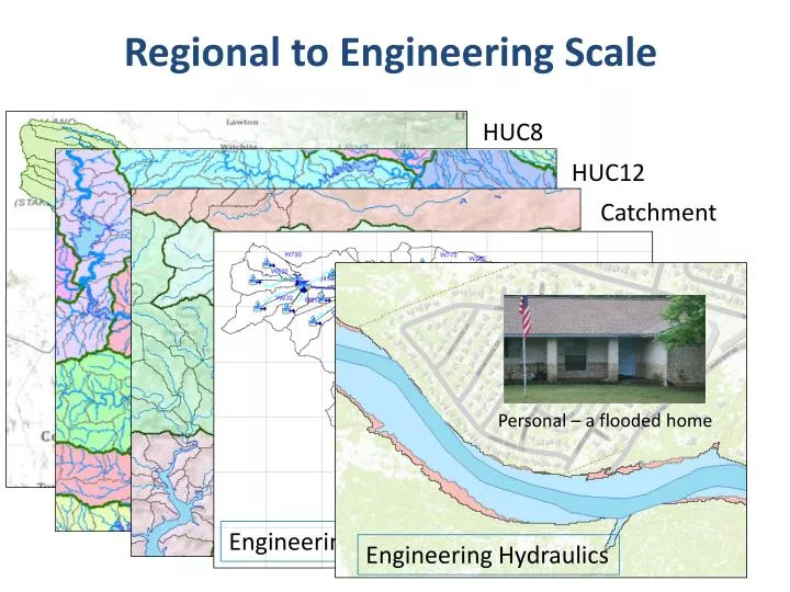
Regional to Engineering Scale. HUC8. HUC12. Catchment. Personal – a flooded home. Engineering Hydrology. Engineering Hydraulics. Tropical Storm Hermine in Texas Sept 7-8, 2010. HUC-12 Subwatershed 120702050401 Upper Brushy Creek. Hermine Flooding. Flood Control Dams.

E N D
Regional to Engineering Scale HUC8 HUC12 Catchment Personal – a flooded home Engineering Hydrology Engineering Hydraulics
HUC-12 Subwatershed 120702050401 Upper Brushy Creek Hermine Flooding Flood Control Dams
GIS Hydrology Analysis (HEC-GeoHMS)using 10ft DEM derived from LIDAR
Engineering Hydraulics Personal – a flooded home
Reaches and Rivers in Brushy Creek Upper Brushy Lower Brushy South Brushy
HEC-RAS Flood Elevation Model using 1 ft DEM derived from LIDAR Cross-Sections for HEC-RAS model
One-Dimensional Flow Computations Cross-section Channel centerline and banklines Right Overbank Left Overbank
Flow Conveyance, K Left Overbank Channel Right Overbank
Reach Lengths (1) Floodplain Lch Rob Lob Floodplain (2) Left to Right looking downstream
Solving Steady Flow Equations Q is known throughout reach • All conditions at (1) are known, Q is known • Select h2 • compute Y2, V2, K2, Sf, he • Using energy equation (A), compute h2 • Compare new h2 with the value assumed in Step 2, and repeat until convergence occurs (A) h2 h1 (2) (1)
Flow Computations Reach 3 Reach 2 • Start at the downstream end (for subcritical flow) • Treat each reach separately • Compute h upstream, one cross-section at a time • Use computed h values to delineate the floodplain Reach 1
Rain Map to Flood Map Connect the Models to Real-Time Observations in Brushy Creek
Brushy Creek in ArcGIS Online http://www.arcgis.com/home/search.html?q=brushy&t=content