Download

1 / 28
280 likes | 304 Views
Learn how to complete a Four-Level Map Analysis (4LMA) by understanding each level's focus from identifying map elements to analyzing patterns and providing plausible explanations. Discover the importance of regionalization and the Distance Decay Model in geography. Practice interpreting maps with real-life examples such as shopping habits and average age of first marriage to enhance your geospatial analysis skills.

E N D
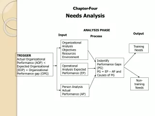
How to complete a Four Level Map Analysis (4LMA): • Level 1 – What am I looking at? Where? When? Scale? • What am I looking at? The best clue for Level 1 is the title, but also include any important identifying features of the map being analyzed (e.g. dates, map scale, type of map, # of classes) • Level 2 – Pattern Identification • What patterns do I see? List any patterns that you recognize. This is the spatial analysis, the heart and soul of thinking like a geographer. Don’t try to explain the patterns you see yet (That’s for level 3.) • Level 3 – Plausible Explanations for Patterns • Why there? For each pattern identified in Level 2 write any plausible explanations you can think of for why that pattern exists (i.e. why that thing is where it is). • Level 4 – Okay…so what? • What surprised you? What will you remember? Why is this important? How does this affect me?
Hmm…”Regionalization is to geography what periodization is to history.” Alexander von Humboldt (1769-1859)
cultural landscape: the visible imprint of human culture and activities on the natural landscape.
(A small clue that cultural landscape may be a central theme in our course.)
The Distance Decay Model is the most basic model in geography for explaining where things are. It is applied here applied to shopping habits.
Why jump scales (view phenomenon at different scales)? Consider this map of average age of first marriage. Look at India. What might you conclude?