Download
1 / 11
110 likes | 290 Views
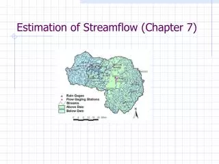
Reduction of Streamflow From Upstream Ice Formation. Brian Connelly North Central River Forecast Center Chanhassen, Minnesota. a.k.a. “Ice Bite”. Ice Bite - What Is It ?. River water temperature is approaching 32°F. An ice cover hasn’t formed on the river yet.

E N D
Reduction of Streamflow From Upstream Ice Formation Brian Connelly North Central River Forecast Center Chanhassen, Minnesota a.k.a. “Ice Bite”
Ice Bite - What Is It? • River water temperature is approaching 32°F. • An ice cover hasn’t formed on the river yet. • An extreme cold snap occurs over the course of a few days. • Cold temperatures rapidly generate a stationary ice cover on the river, and freeze some water sources. • Since the river ice is stationary it is removed from the downstream flow, and river levels can drop rapidly.
Ice Bite – Who Cares? • Low water event, not flooding • An ice bite can have temporary but significant impacts on navigation, municipal water supplies, and power plant operations. • River levels typically rebound somewhat after a few days.
Ice Bite Example • St. Louis, Missouri – January, 2003 • Lower than normal precipitation during summer and fall of 2002 • Low water entering winter season • Concern over navigation
Forecasting Ice Bite • Monitor Conditions • Significant portion of river must be ice free • River water temperature must be at or near freezing • Watch air temperature forecasts for prolonged cold snaps • Rule of Thumb • Flow reduced by 50% • Rebounds to about 75% of original flow • Source: Wise forecaster from the NCRFC
Conclusions • Process isn’t modeled, but it may be possible to predict using an approach similar to some of the ice jam prediction methods. • Potential RFC Forecaster Aids • Plot latest water temperature observations spatially. • Plot latest ice cover/thickness observations spatially. • Plot forecast freezing degree days spatially. • Refine the rule-of-thumb