Download
1 / 17
170 likes | 351 Views
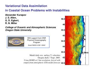
Development of coastal altimetry and perspectives for data assimilation in coastal domain. Matthieu Le Hénaff (1) and many more… (1) RSMAS, Miami, FL. Outline Historical perspective from a user point of view Example of the Florida Keys area as a potential test-bed for coastal altimetry

E N D
Development of coastal altimetry and perspectives for data assimilation in coastal domain Matthieu Le Hénaff(1) and many more… (1) RSMAS, Miami, FL
Outline • Historical perspective from a user point of view • Example of the Florida Keys area as a potential test-bed for coastal altimetry • Perspectives for data assimilation and conclusion
Recent developments in coastal altimetry • Improving 2D maps • by using tide gauges along the coast (Saraceno et al., 2008, Wang et al., 2011) (right) Example of interpolation of (left) AVISO SLA and currents based on the use of tide gauges data (middle). From Saraceno et al., 2008. • Improved along-shore currents
Recent developments in coastal altimetry • Improving 2D maps • by using shorter correlation scales, in combination with multi-mission dataset (Dussurget et al., 2011): mesoscale Example of optimal interpolation of HF along-track data to access mesoscale dynamics. From Dussurget et al., 2011.
Recent developments in coastal altimetry • Improving 2D maps • Limitation of such approach: interpolation leads to smoothing of the signal, with final scales that may not be adapted to the study zone, esp. near the coast (anisotropy) • Improving along-track data • First developed in the Mediterranean Sea, in the Capraia Island area (bwn. Italy and Corsica) • use of raw data with improved data flagging (Vignudelli et al., 2000): retrieve steric signal in SLA • improved tidal and atmospheric corrections (Vignudelli et al., 2005): currents at seasonal scale • use of high resolution data (10, 20 Hz) (Bouffard et al., 2008) Location of the Capraia Island. From Vignudelli et al., 2005. Improvement of data coverage in the Capraia Island area. From Bouffard et al., 2008. Estimation of the geostrophic velocities anomalies. From Bouffard et al., 2008.
Recent developments in coastal altimetry • Improving along-track data • “recipes” tested in other areas: • Bay of Biscay (NE Atlantic): characterization of the Navidad Current (North of Spain) (Le Hénaff et al., 2011, Herbert et al., 2011) • India: study of the East India Coastal Current (EICC) (Durand et al., 2009) • West Florida Shelf: performance assessment over a wide shelf (Liu et al., 2011) Signature of the Navidad Current in along-track geostrophic current anomaly and SST. From Le Hénaff et al., 2011. Structure of the EICC. Adapted from Durand et al., 2009. HF radar radial velocity with satellite tracks. From Liu et al., 2011.
On-going developments in coastal altimetry • Still about the improvement of along-track data: • waveform analysis (PISTACH, COASTALT) • wet tropospheric correction (PISTACH, COASTALT): • - better account for land in the altimeter footprint (Desportes et al., 2007) • - combine altimeter radiometer measurements, local measurements and improved atmospheric models (Fernandes et al., 2010) Zenith wet delay (ZWD, m) from the GPD method (black), the inboard radiometer (red) and ECMWF model (blue). Green area are polar/coastal zones. Adapted from Fernandes et al., 2011.
On-going developments in coastal altimetry • mean sea surface (several datasets) • dynamic atmospheric correction (DAC): • - signal due to wind and pressure removed with barotopic model (Carrère and Lyard, 2003) • - today: global model real-time products; delayed-time?; regional model soon? • tidal correction: • - today: global tidal model in many zones; nested high-resolution DA regional model (G. Egbert, 2011 Coastal Altimetry Workshop recommendation) • - along-track harmonic analysis Short-term perspectives • all these upgrades have to be evaluated • the evaluation phase has to take into account local conditions (bathymetry, currents etc.) Configuration of in-situ moorings array under a Jason track. From Beal et al., 2009.
Example of a possible test bed: the Florida Keys area • Complex topography • broad SW Florida shelf and Florida Bay • narrow Atlantic Florida Keys shelf • deep Straits of Florida • Complex dynamics • wind-driven shelf flows • buoyancy-driven shelf flows (river runoffs) • intense coastal to offshore interactions: Florida Current front and eddies Adapted from Lee et al., 2002.
Example of a possible test bed: the Florida Keys area • Jason track 102 is perfectly oriented: perpendicular to the bathymetry and the main current orientation Apr 25 - salinity SSH (cm) from the HYCOM-FKeys simulation on Aug 28, 2009. Isobaths (black) are 200, 500 and 2000m. HYCOM-FKeys SSH w/ surface currents.
Example of a possible test bed: the Florida Keys area Apr 22 Apr 23 Apr 24 HYCOM-FKeys SSH w/ along-track 5 Hz surface currents. • observe the Florida Current in details • able to observe meso-scale eddies along the Keys (right timing)
Example of a possible test bed: the Florida Keys area 5 Hz coastal data Standard 1 Hz data • standard altimetry misses the eddy • => The detection of small frontal eddies is possible thanks to: • data availability closer to the coast • high rate data HYCOM-FKeys SSH w/ along-track 5 Hz surface currents (left) and 1 Hz currents (right)
Example of a possible test bed: the Florida Keys area • Validation opportunities: • in-situ mooring (Looe Key, 30 km upstream) • high resolution ocean color and/or SST maps (GHRSST) CR SW FL Shelf SR B1 A1 B2 C2 smk DT san LK Location of in-situ moorings along the Florida Keys. Provided by C. Hu (USF/IMARS) • ideal strategy…
Example of a possible test bed: the Florida Keys area • What can we expect from such dataset? • medium to long-term trends (long time series) • isolated event (when simultaneous with obs) • limitation: one track every 10 days (Topex-Jason orbit) • > lucky to observe short-term event (eddy passage, wind burst current) Location of Jason 2 (red), Jason 1 (magenta), Envisat (yellow) and GFO (green) tracks. … but with multi-satellite: more opportunities for detection
Example of a possible test bed: the Florida Keys area • Connection to models • first: compare the physical content of the model and the observations (need complementary data) • long-term: assimilate the data and see how they affect the simulation • existing issues with data assimilation in coastal areas: • coastal areas (shelf and near-shelf areas): superposition of multiple scales • adapt the assimilation strategy: observation data treatment and covariance scales (Yi Chao); 5th coastal altimetry workshop recommendation • need multivariate DA to constrain the model (A. Kurapov; 5th CAW) • tides: how do we assimilate SLA in the presence of tides? • large signal on shelf areas; largest tidal model errors • 1st idea: remove the tidal signal from the model before assimilating de-tided SLA (Xie et al., 2011). How can we optimize such filtering? Do we lose some information? • the tidal signal is included in the altimetric data themselves: can we use that information directly? • idea: correct the tidal boundary forcing (Barth et al., 2011, HF radar); possible to correct bathymetry (Mourre et al., 2006)? • open questions, crucial when it comes to assimilating altimetry in shelf areas
Conclusions: • Coastal altimetry is recent: need for users to know the content of the products (corrective terms) • Achievements so far: • 2D: extend SLA to the coast, improve the resolution • along-track: validation, derive geostrophic current in poorly or uncovered areas • still a big effort for the assessment; need collaboration between users and data providers; benefit for SWOT • Florida Keys area: • multiple scales (Western boundary current, eddies, shelf dynamics) • perfect orientation of Jason 2 track • expected improvements by coastal altimetry (presence of the Keys islands, adapted corrections) • Long-term objective: data assimilation • adapted multi-scale strategy • treatment of the tidal signal is a major issue