Download
1 / 5
50 likes | 62 Views
Analyzing vegetation differences using Channel 2 (0.8 µm) and Channel 1 (0.6 µm) on MSG-1 satellite imagery at various dates and times. Explore vegetation changes through visual comparison and monitoring techniques.

E N D
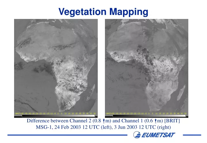
Vegetation Mapping Difference between Channel 2 (0.8 m) and Channel 1 (0.6 m) [BRIT] MSG-1, 24 Feb 2003 12 UTC (left), 3 Jun 2003 12 UTC (right)
Vegetation Mapping Difference between Channel 2 (0.8 m) and Channel 1 (0.6 m) [BRIT] MSG-1, 3 Jun 2003 12 UTC (left), 25 Jun 2003 10 UTC (right)
Vegetation Mapping Difference between Channel 2 (0.8 m) and Channel 1 (0.6 m) [BRIT] MSG-1, 24 Feb 2003 12 UTC (left), 24 Apr 2003 12 UTC (right)
Vegetation Mapping Difference between Channel 2 (0.8 m) and Channel 1 (0.6 m) [BRIT] MSG-1, 24 Feb 2003 (left), 27 March (middle), 24 Apr 2003 (right)
Vegetation Mapping Channel 12 (HRVIS) Difference Ch02-Ch01 RGB Ch12_Diff02-01_Ch12 Vegetation Monitoring using MSG Visible Channels, 3 June 2003, 12 UTC