Download
1 / 15
150 likes | 175 Views
WMO Interoperability – the vision Gil Ross (Met Office UK). Metadata workshop; Beijing. The “Vision” Thing -. The “Vision” Thing Bush – the Elder NOT Pliny the Elder or Pitt the Elder But I’m not any of them So Can I articulate a WMO vision?. WMO Interoperability.

E N D
WMO Interoperability – the vision Gil Ross (Met Office UK) Metadata workshop; Beijing
The “Vision” Thing - • The “Vision” Thing • Bush – the Elder • NOT Pliny the Elder or Pitt the Elder • But I’m not any of them • So • Can I articulate a WMO vision?
WMO Interoperability • WMO is HIGHLY interoperable • for over 50 years • but in a closed user group • which is admittedly large (187 member states) • but which mainly talks to itself • WMO has its own processes and protocols • and formats • and data types • and networks • and software • and justified self-importance (but too much …)
Surface Observations 0000Z 20th September http://www.metoffice.gov.uk/research/nwp/observations/data_coverage/index.html
Aircraft Observations 0000Z 20th September http://www.metoffice.gov.uk/research/nwp/observations/data_coverage/index.html
WMO Interoperability • But this isn’t the big-wide-world • It isn’t even all WMO Commissions • We need even better interoperability • in WWW • with the rest of WMO • with USERS of our data • with cheap software • on everybody’s laptop • Isn’t this the remit of the National Centres? • I’d say – NO.
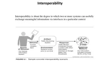
Interoperability • Consider the following graphic. • It happens to be created by MetO but • It has a map background, • Some contours, that has access to, • Data, • Sensible weather objects created by a forecaster, but could be another Met Service, • A legend including a logo.
WMO Interoperability World Weather Watch NMS Climatology Oceanography Agriculture etc.etc. The Big Wide World
Standards and Interfaces • TBWW has standards and interfaces which are becoming ubiquitous and cheap • Specialised formats are being ignored, circumvented and made obsolete • specialised formats and protocols do have their place in closed systems – e.g. GTS • however they should be presented externally in more widely recognised standards • So WMO should have unified standards to present data and services to TBWW
And… • don’t pay for development costs (not all) • implementation costs are cheaper • software we develop and use can be universal • economies of scale • choose successful standards • rather than be bleeding edge • ride the wave rather than buck the trend • expect to follow industry upgrade paths • secure(r) future
Standards and Interfaces • What are these standards? • Most likely • Web Services • data GRID • OGC and ISO • Catalogue services • WMS – web mapping service • WFS – web feature service • WCS – web coverage service • XML – GML • Catalogues and repositories
Catalogues and repositories • metadata catalogue • feature catalogue • schema repositories • vocabularies • Question - What is the difference? • Answer - it isn’t entirely clear and - there isn’t a unique answer • Identifiers (not file naming system) • gazeteers • locations • CRS coordinate reference systems • service catalogues WMO already does this but not in the modern way
What do we do now? • Get involved • Develop content for the catalogues • Metadata • Features and coverages • Observations and Measurement • CSML • GML • Gazeteers • Vol 9 is good • ICAO codes – not good • CRS definitions
What do we do now (2) • Vocabularies • communityTopicCategory and keywords - a WMO taxonomy • Parameter lists, definitions • GRIB and BUFR tables • WWW usage • CF convention for netCDF • Climatology and Oceanography usage • Develop services – at NMS level and get involved again - a number of different contexts