Download
1 / 9
90 likes | 107 Views
Learn about the crucial role of NOAA Foundation CORS in providing reliable geodetic data for the new NSRS. Explore the network's setup, operational goals, and significance in international positioning consistency efforts.

E N D
The NOAA Foundation CORS Network Theresa Damiani, Ph.D. Chief, Spatial Reference System Division May 7, 2019 NGS Geospatial Summit
Outline What are the Foundation CORS? How are they different from other CORS? Why do we need them?(a.k.a. How the new NSRS is made) What does NGS have underway?
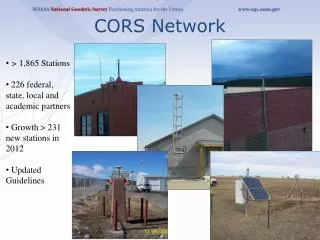
What are the Foundation CORS? A set of federally-operated, ultra-high-quality, high-reliability stations with the longevity to guarantee citizens access to official NSRS positions and support international positioning consistency efforts. 26 in North America, 4 in the Pacific, 3 in the Caribbean, and 3 in the Marianas.
How are they different from other CORS? • Federally-owned and operated “backbone” • Chosen for location, longevity, and high quality • Operational Goals: • Non-operational time minimized for each station • 90% of NOAA Foundation CORS Network available at any time (no more than 4 stations non-operational) • All stations are critical to some function of the new NSRS • 22 out of 36 stations are (currently or will be) co-located with other space geodetic stations supporting the IGS/ITRF • Local tie surveys (“IERS site survey”) will link together all geodetic instruments/marks at the site every 5 years.
Why do we need them? A.k.a.How will the new NSRS be made? “The new *TRFs will be plate-fixed and aligned to the IGS densification of the ITRF.” WHAT DOES THAT MEAN??? An international science service does this, relying on data contributed from agencies all over the globe and from several space geodetic instruments, including GNSS. A reference frame starts with defining the planet’s size and shape. This allows exact values of latitude, longitude, and height to be assigned to places. International GNSS Stations (IGS) included in ITRF 2014
How will the new NSRS be made? The IGS uses the ITRF stations as “known” locations and calculates/aligns additional IGS stations to those ITRF stations-- a process called “densification”. NGS uses the IGS stations (some are CORS) as “known” and aligns all the NOAA CORS to them*. And so on… other federal, state, local, and private GNSS networks align to the NOAA CORS…
How will the new NSRS be made? The ITRF is designed to be global and does not account for tectonic plate motions. The NSRS needs to model and remove those motions to provide locations useful for surveying. North America and Pacific are well-represented. Need a minimum of 3 stations per plate, far apart if possible.
Why do we need Foundation CORS? The Foundation CORS targeted locations provide: • A geographic distribution no greater than 800 km to provide 1.5 cm accuracy ellipsoidal height results through NGS’ OPUS tools anywhere in the U.S. • Support for the ITRF by co-locating at existing space-based geodetic sites. • Favorable geometry to monitor tectonic plate (Euler Pole) rotation. • Gap Filling in international areas where foundational stations are needed to support the U.S. NSRS, e.g. Caribbean
Foundation CORS Development Underway Phase 1:Incorporate partner stations Existing NASA, NSF, and Caribbean partner stations brought into the Foundation CORS network. Phase 2:Upgrade existing NGS CORS Upgrades include fully-GNSS equipment and submission to IGS to meet Foundation CORS requirements Phase 3: Construct ~8 new stations These NGS-owned stations will all be co-located at sites with other existing space geodetic techniques. Foundation CORS at NGS’ Table Mountain Geophysical Observatory in Boulder, CO (ID: TMG2)