Download
1 / 17
170 likes | 254 Views
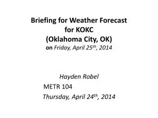
Weekly Weather Briefing “Back to Springlike ” NWS Albuquerque February 10, 2014. Angel Fire. 28°F. 43°F. 25°F. 54°F. Las Vegas. 50°F. 27°F. 58°F. 23°F. Ruidoso. 59°F. 34°F. Visible Satellite Image 12:30pm MST 1:00pm MST Temperatures. Most Recent Temperatures.

E N D
Weekly Weather Briefing “Back to Springlike” NWS Albuquerque February 10, 2014
Angel Fire 28°F 43°F 25°F 54°F Las Vegas 50°F 27°F 58°F 23°F Ruidoso 59°F 34°F Visible Satellite Image 12:30pm MST 1:00pm MST Temperatures
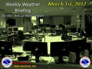
Percent of Normal PrecipitationJuly 2011 to December 2013 UT CO AZ NM
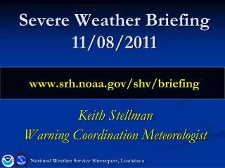
Winds at a glance THU MON TUE FRI Surface to 10kft Mean Wind Speed (kts) WED SUN SAT
NEW Mobile Friendly Web Page & Widget Page dynamically scales to the display size (adaptable to desktops, tablets, and mobile phones) Can also be embedded in a web page as a "widget“ using this code: <iframe width="250px" height="620px" overflow-x:hidden; overflow-y:hidden; border:0px src="http://innovation.srh.noaa.gov/NWSwidget/?lat=35.11&lon=-106.61&widgetMode=1"> </iframe> http://innovation.srh.noaa.gov/NWSwidget/about.php
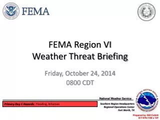
Significant Warm-up after Wednesday Forecast Highs Today Forecast Highs Saturday
Upper Level Forecast Chart(Image is Moisture) Tonight Tonight: Areas of mainly light snow across portions of northern and eastern NM as a quick-hitting disturbance drops out of Colorado. Only light/minor accumulations, if any.
Upper Level Forecast Chart(Image is Moisture) Tuesday Tuesday: Predominately dry northwest flow aloft. Patchy flurries or light snow lingering east early. Otherwise, a few flurries possible northern high terrain. Temperatures warmer east, and near to slightly above seasonal averages west.
Upper Level Forecast Chart(Image is Moisture) Wednesday Wednesday: Northwest flow aloft continues. Temperatures continue to warm with daytime readings above average most areas.
Upper Level Forecast Chart(Image is Moisture) Thursday Thursday: Weak disturbance(s) to clip far northern NM but impact minimal except for enhanced windiness mountains and east.
Upper Level Forecast Chart(Image is Moisture) Friday Friday: Anomalously strong ridge developing over northern Baja begins to build northward.
Upper Level Forecast Chart(Image is Moisture) Weekend Outlook Saturday Sunday Weekend: Upper ridge dominates the southwest U.S. Temperatures well above average. Moderate breezes northern mountains and northeast.
Week at Glance Tonight-Tuesday Quick hitting disturbance to bring areas of light snow to portions of the north and east. Wednesday-Friday Warmer with bouts of windy conditions mainly mountains and east. WeekendDry and warm!
As always… Stay up to date… weather.gov/abq Facebook @NWSAlbuquerque & #nmwx NOAA Weather Radio Favorite Media Outlet mobile.weather.gov NMroads.com