Download
1 / 40
400 likes | 533 Views
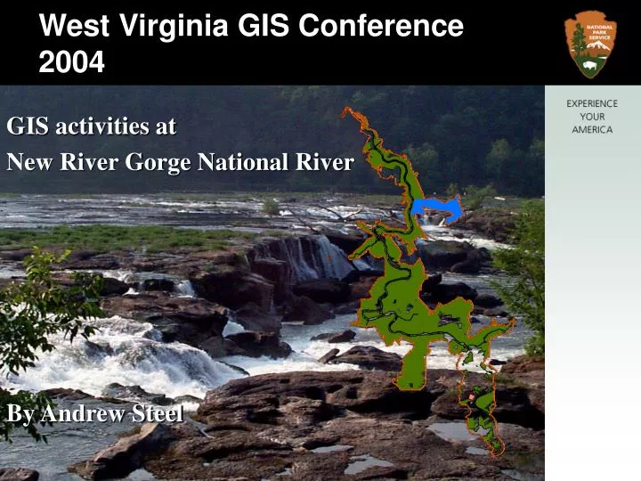
West Virginia GIS Conference 2004. GIS activities at New River Gorge National River By Andrew Steel . Background. New River Gorge National River (NERI) established in 1978 to preserve and protect 53 miles of the free-flowing New River in West Virginia.

E N D
West Virginia GIS Conference 2004 GIS activities at New River Gorge National River By Andrew Steel
Background • New River Gorge National River (NERI) established in 1978 to preserve and protect 53 miles of the free-flowing New River in West Virginia Grandview OverlookNew River Gorge National River • GARI/BLUE added in 1988 • NERI/GARI/BLUE total approximately 88,000 acres
Our Enabling Legislation • “For the purpose of conserving and interpreting outstanding natural, scenic, and historic values and objects in and around the New River Gorge and preserving as a free-flowing stream an important segment of the New River in West Virginia for the benefit and enjoyment of present and future generations, the Secretary shall establish and administer the New River Gorge National River.”
Statistics for New River Gorge • 72,189 acres • 51,469 acres in federal ownership • 3,587 acres within state parks • 162 acres within scenic easement • 184 miles of boundary • 339 miles of property lines
Bluestone National Scenic River Statistics for Bluestone • 4,336 acres • 3,055 acres in federal ownership • 1,238 acres within state parks • 29.5 miles of boundary
Gauley River National Recreation Area Statistics for Gauley • 11,507 acres • 4,309 acres in federal ownership • 66 miles of boundary • 76 miles of property lines
Visitation to three park areas average over 1.5 million Canyon Rim Visitor CenterNew River Gorge National River
Visitor Use Thousands of whitewater enthusiasts come to enjoy the excitement… • 145,000 New River • 62,600 Gauley River Whitewater RaftingNew River Gorge National River
Visitor Use….rock climbers come from around the world .….over 1600 named routes both traditional and sport climbs rated 5.6- 5.14 Climber at Bridge ButtressNew River Gorge National River
Visitor Use….base jumpers come from around the world to attend the annual Bridge Day….this past year over 125,000 people attended Taking the Leap on Bridge DayNew River Gorge National River
Forested Lands Agricultural Lands Archaeological sites Historic structures Water Resources Rare & Endangered Plants Historical Landscapes Recreation Rare & Endangered Animals Geologic Resources Ecological Integrity Biological Diversity Aquatic plants and animals Cultural Sites Resources we manage at New River:
Forested Lands New River Gorge National River
Agricultural Lands Historic Ballard Farm
Rare and Endangered Plants Virginia Spiraea
Rare and Endangered Animals Rafinesque’s Big-eared Bat Woodrat
Geologic Resources Avis Limestone near the town of Sandstone. This was originally deposited by an ancient ocean. (West Virginia Geological Survey)
Accomplishments • Acquired spring and fall 2003 aerial photography for the three parks • Produced all geospatial data needed for work on the Gauley river National Recreation Area Development Concept Plan • Acquired, compiled, and organized data potentially needed for upcoming New River Gorge National River General Management Plan Review
Goals • Landscape change analysis for the New River Gorge National River • Contractor working on vegetation layer for New River Gorge National River • Mapping of trails and facilities within the park along with updating the roads layers for New River Gorge National River
Question Andrew Steel New River Gorge National River P.O. Box 246 Glen Jean, WV 25846 304-465-6556 andy_steel@nps.gov • For more information please visit our web site at: www.nps.gov/neri/home.html View from Beauty Mountain Looking NorthNew River Gorge National River