Download
1 / 18
800 likes | 2.71k Views
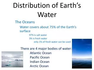
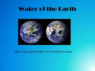
Distribution of Water on Earth. Chapter 1C - Hydrology Messana Science 8. THIRST VIDEO. http://www.slideshare.net/jbrenman/thirst. Saltwater. Oceans cover 71% of Earth’s surface ( about ¾ ) Land takes up 29% of Earth’s surface ( about ¼ )

E N D
Distribution of Water on Earth Chapter 1C - Hydrology Messana Science 8
THIRST VIDEO • http://www.slideshare.net/jbrenman/thirst
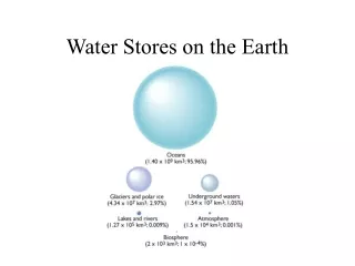
Saltwater • Oceans cover 71% of Earth’s surface (about ¾) • Land takes up 29% of Earth’s surface (about ¼) • 2 categories of water in the Hydrosphere…based on Salinity = % salt content • Saltwater: • 97% of Earth’s water • Oceans • 35 g salt/kg of water • How many oceans are currently recognized today??!!
Freshwater • Freshwater: • < 1 g salt/kg of water • ONLY 3% of Earth’s water is fresh • 2/3 of that is frozen in glaciers, ice caps, & icebergs (pieces of glaciers floating in ocean) • 1/3 of that is liquid & accessible in lakes, ponds, rivers, streams, or underground
Water Cycle – Quick Review • 1. Sun heats the water on the surface of Earth • 2. Freshwater evaporates into atmosphere as water vapor (salt in ocean stays behind) • 3. Water vapor cools & condenseson dust particles to form clouds • 4. Water falls back to Earth as precipitation in the form of rain, sleet, snow, or hail • 5. Precipitation that hits surface either gets absorbed into ground, stays trapped as standing water, or moves downhill as “run-off” back into lakes, ponds, rivers, streams, oceans **The amount of water on Earth stays the same!!**
Water Drainage Patterns • Precipitation hits the surface of Earth • 1.) If Permeable/Pervious Surface = water will sink in • 2.) IfImpermeable/Impervious Surface = water will not sink in, may be trapped in basin OR may run off from high low elevation
Water Drainage Patterns • Divide = high ridge of land from which water will flow in different directions • Watershed/River Drainage Basin = drainage area where all water from one side of a divide flows, all water flows to one central river based on the topography (curves/elevation) of the land • What River Basin do we live in?? • Catawba River Wateree River Santee River Atlantic Ocean!
Possible Water Flow Example • Precipitation • Land • Flows Downhill • Stream • River • Larger River OR Lake • Estuary= mix of fresh & salt water in a bay • Ocean!!...all water ends up here
Groundwater • Water that seeps into the soil & is pulled down by gravity • Can move or sit under the surface if there are spaces between the rock/soil particles (permeable) • Water will seep down until it hits an impermeable surface, then fill up from there (like your bathtub with the drain closed!) • The region filled with ground water = Saturation Zone • The top surface of this area = Water Table
Aquifers • Underground permeable rock or sediment that contains water • Particles in ground act like filter to water!!
Ogallala Aquifer – under U.S. • Huge source of freshwater for drinking & irrigation in the U.S. • Depleting at alarming rate… • “The average annual depletion rate between 2000 and 2007 was more than twice that during the previous fifty years!”
Groundwater to the Surface Via… • 1.) Man-made Well – pipe dug into ground to extract water from aquifer • 2.) Artesian Well – water flows naturally to surface because it’s under pressure • 3.) Spring– water flows to surface because surface of land dips below water table • 4.) Hot Spring/Geyser – water heated up by rocks, pushes up to surface due to pressure
Geyser in Iceland – YouTube Clip • http://www.google.com/url?q=http://www.youtube.com/watch%3Fv%3DW-daow-LojM&sa=U&ei=n65CT8aeApDcgge2o63lCw&ved=0CCgQtwIwAg&usg=AFQjCNEpLlDlSzVPx4aS-Tu3nfBc1pCkKw • http://www.youtube.com/watch?v=tShhZvvIM84&feature=related
http://www.youtube.com/watch?v=wJ3CKgZEitw&feature=player_embedded#!http://www.youtube.com/watch?v=wJ3CKgZEitw&feature=player_embedded#! • http://www.youtube.com/watch?v=gTqLQO3L4Ko