Download
1 / 31
310 likes | 333 Views
Explore the intricate dynamics of waves, erosion, and coastal engineering to safeguard coastal regions from natural hazards and human intervention. Learn about key features and precautions for coastal safety.

E N D
Coastal Process Chapter 9:
Wave Dynamics • Wave length (L)= Distance between crests, • Wave height (H) = Vertical distance between the crest and the trough • Wave base = depth below which waves have no effect = ½ * wave length Period (T)= Time taken for two successive waves to pass a point Velocity (V) = L/T
Breakers form when the sea-bottom is at a depth less than the wave base • Surf Zone = Zone along which breaking waves collapse • Swash and backwash = up and down movement of water along the shore line
Sydney, Australia Notice the surf zone and also the rip currents
Berm Offshore = Farthest out, beyond surf zone Foreshore = surf zone, tidal flat and swash zone Backshore = Inwards from Foreshore upto the coastal dunes
Virginia Keys What is the direction of the Longshore Current?
Commenced 1970 s • $62 million over 10 years, 160 K m3 of sand • 18 million m3 of sand dredged and pumped • 200 m wide beach by 1980s
Miami Beach Berm Swash Zone
Nature of Coast Line • Active Margin • Western Coast of USA • Steep Continental Shelf • Narrow beach • Rocky cliffs • Passive Margin • East Coast • Wide, gentle beach, sandy offshore islands • Broad Continental Shelf
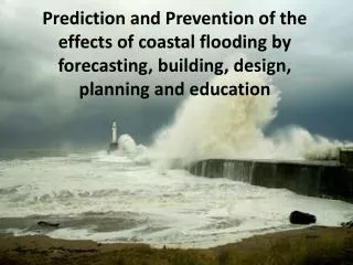
Coastal Hazards • Sea Level Rise • Hurricanes, Storm surge • Recognition of coastal hazards
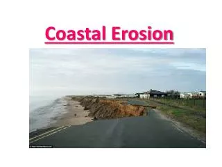
Coastal Erosion • Human modification has accelarated erosion • Coastal Engineering structures e.g., sea walls • Damming of rivers • Subsidence due to withdrawal of groundwater, oil etc
Do you know this place? Spit • Depositional Landforms: • Spits = narrow extension of beach formed by longshore current • Barrier Island = sandy offshore islands parallel to the shoreline
Safety concerns • High elevation (>5 m) above normal high tide • Well developed beach dunes between the site and the water-line • Overall water level – maximum storm-surge limit • Emergent or Submergent coast? • Rate of coastal erosion (from USGS and county maps)