Download
1 / 26
260 likes | 364 Views
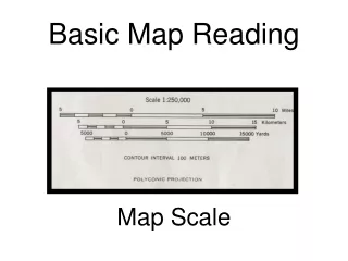
Map Reading Section 3 - B. Continuation of Compass section. Finding your location. Suppose you are lost and know that you are located someplace on this map You can see two mountains that show up on your map

E N D
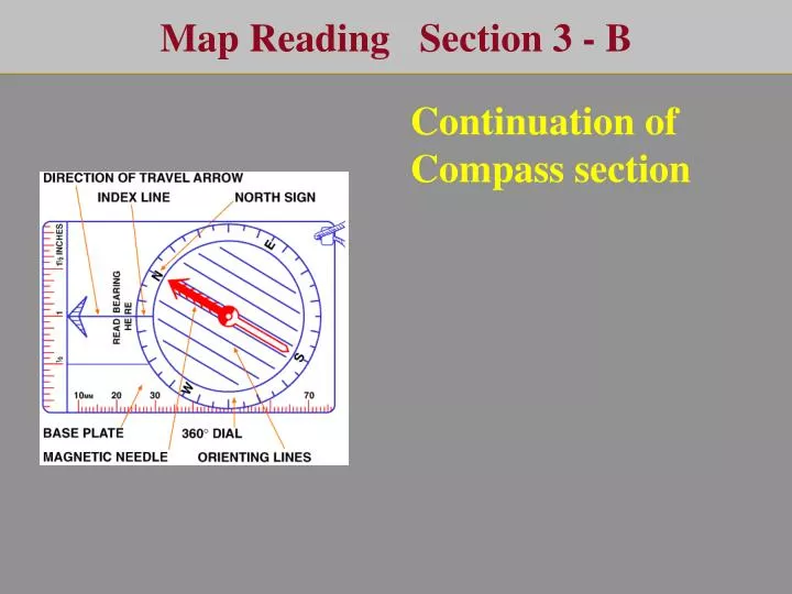
Map Reading Section 3 - B Continuation of Compass section
Finding your location • Suppose you are lost and know that you are located someplace on this map • You can see two mountains that show up on your map • If you had the skill to measure the two lines as shown, you could find your location by the intersection of the two lines • Let’s do it
Measure a Bearing • Line up your compass with the red MN needle pointing towards the North sign on the compass • Point the compass towards the top of the mountain • Read the baring to the top of the mountain • Do this for both mountains
You now have two bearings but You could be anyplace on the map
You know Round Mt is 180o bearing from your location • But, you don’t know your location • You do know the location of Round Mt • You are going to have to measure from Round Mt
Drawn a 138o line from the top of Round Mt • This line is going in the wrong direction • You calculated the bearing from you to Round Mt, not the other way around
You are off by 180 so do the math 138 + 180 =318
0 360 Place a protractor on Round Mt and mark 318 315 45 90 270 135 225 180
0 360 90 270 180 138 + 180 =318 Draw a 318o line from R.M.
I you don’t have a protractor when in the field, you can make one. Trace a water bottle or a compass onto a piece of paper
0 360 Draw the lines 180
0 360 90 270 180
0 360 315 45 90 270 135 225 180
0 360 315 45 90 270 135 225 180
138 + 180 =318 You have a magnetic bearing, but to draw on a map you have to convert
0 360 90 270 180 TB = MB + D MB = TB - D 138 + 180 =318 318 + 10 =328 You now can draw your line
138 + 180 =318 TB = MB + D MB = TB - D 318 + 10 =328 196 + 180 =376 376 –360 = 16 16 + 10 = 26 Now do the other mountain
Additional Pointers • Some compass's have a built in declination adjustment. • You set the 10o and the compass converts declination • for you. • Don’t forget to adjust this if you are not in CB. • If using old maps, update the declination by using key words “magnetic declination “ on the internet. • You must orient your map.
Orient the Map Once in the field you must orient the map. Place your compass on the map near the declination marking TN
Turn the map till the red line on your compass lines up with the grid on your map TN MN
The map is oriented with TN but if you don’t have declination built into your compass, you must turn the map more to line up with MN TN MN
Your map is now oriented You are ready to navigate TN MN
Traveling with a compass Determine the bearing you will travel. Select a landmark in the distance that lines up with the bearing. This can be a mountain, or in the dark it could be a partner with a light. Travel towards the distant landmark … this prevents you from always looking at the compass. Occasionally check the compass and select a new target when necessary. When going around an obstacle (such as a pond or a hill) select a landmark on the other side. Travel to the landmark and when you arrive select a new landmark as your target. You can use time to measure the distance traveled … you can travel about 1 to 2 miles per hour on a trail but less than this if you are bushwhacking.
End of Compass Section Next section G. P. S. Global Positioning System


![Section E Reading Skills- Referents [B(g)]](https://cdn2.slideserve.com/4000285/section-e-reading-skills-referents-b-g-dt.jpg)