Download
1 / 28
280 likes | 314 Views
NCMGC supports Surface Mining Control and Reclamation Act by enhancing analysis, decision-making, and reducing risks. Membership includes interstate organizations, aiming to improve coal mining data stewardship.

E N D
Who Does NCMGC represent? • Department of the Interior’s Office of Surface Mining (=OSM) • Headquarters, • Regional offices (3), & • Field offices in coal producing regions of the US. • Coal producing states (23) • Native American tribes (5) • Coal producers • The public
Purpose of NCMGC • Promote development of geospatial technology to support Surface Mining Control and Reclamation Act (=SMCRA) • Help migration OSM’s Technical Innovation & Professional Services (=TIPS) users to enterprise GIS • Improve business processes
Benefits of NCMGC • Provide sound scientific information • Enhance analysis • Improve understanding • Better decision-making • Reduce risk • Meet requirements with available resources • Reduced budget • Limited personnel • Find qualified geospatial expertise • Share technological successes • Share government information resources • Compliance with federal data requirements
NCMGC Members • Interstate Mining Compact Commission (=IMCC) Larry Evans, WV • National Association of Abandoned Mine Lands Program (=NAAMLP) Doug Mullins, VA • Western Interstate Energy Board (=WIEB) Rick Koehler, NM • OSM/Appalachian Bill Card, TN (Chairman) • OSM/Mid-Continent Len Meier, IL • OSM/Western Alan Wilhelm, CO • OSM HQ Vacant
History • May 4, 2005 – Office of Surface Mining (=OSM) Director TIPS Steering Committee approved creation of the NCMGC. • August 15, 2005 – 1st NCMGC teleconference • September 13, 2005 – 1st NCMGC meeting in Denver • January 11 & 18, 2006 – OSM regional managers briefed • February 28, 2006 – meeting in Santa Fe, NM • March 24, 2006 – Geospatial Questionnaire released
Technical Support Group • Subject matter experts • Extension of committee • Advise committee on technical matters • Short term tasking • Cooperation among TSG members promotes sharing of technology
Communicating about NCMGC • Internal website for committee members • Operational • External website for public access • Web pages in draft, under review • Contained on TIPS website (http://www.tips.osmre.gov)
FY 2006 Significant Activities • Support OSM MCR geospatial infrastructure • SMCRA Geospatial Technology Development Questionnaire (issued March 24, 2005) • National Meeting of SMCRA Geospatial Data Stewards week of June 27-28, 2006 • Microsoft SQL Server Training • Possible ESRI ArcSDE training at Mid-Continent Region • Prototype SMCRA geospatial infrastructure
Highlights of Questionnaire Results • 42 responses from SMCRA organizations • 38 geospatial data stewards identified • 38 SMCRA organizations use GIS • 13 do not use MS SQL Server or Oracle • 28 do not use ArcSDE • 29 do not share spatial data by Internet • 33 do not have a written plan
Coal Mining Data is a National Asset • Executive Order 12906 • Public access to geospatial data Sec. 3(c) • OMB Circular No. A-16 • Themes of national significance Sec 2.b.(1) and Appendix E • Applies to all agencies using geospatial data Sec 5. • Applies to all spatial activities funded with federal funds Sec 6. • Agency responsibilities and reporting Sec 8.a. • Spatial data are subject to Exhibit 300 Sec 8.b.
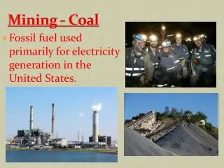
Coal Mining Data Examples • Mining boundaries • Permit, critical earth fills, sediment basins, haul roads, etc. • Geologic drill holes • Surface water monitoring locations • Ground water monitoring locations • Underground mining extents • Underground mine entry locations
Initial Coal Mining Datasets • Datasets common to SMCRA workers • Surface mining boundaries • Underground mining boundaries • Quick index to location of other coal mining data • Geographic locator of potential impacts
Surface Mining Boundaries Surface mining boundaries are polygons representing the boundary of the permitted area of a surface coal mining operation as described on the most recent mining operations map contained in a coal mining permit approved by the regulatory authority. Each approved permit has a single record in a spatial database of surface mining boundaries. Each record in the spatial database identifies the permit number of the surface coal mining operation and contains one or more polygons identifying the areas for conducting surface coal mining operations approved by the regulatory authority.
Underground Mining Boundary Underground mining boundaries are polygons representing the boundary of the underground mine workings of an underground coal mining operation as described on the best available mine workings maps. Each mine has a single record in a spatial database of underground mining extents. Each record in the spatial database identifies the underground coal mining operation and contains one or more polygons identifying the areas of underground mine workings.
The Problem … How can TIPS users organizations implementing GIS partner together more effectively? Time for a “geospatial collective” mindset
Citrix (terminal services) • Citrix is hugely successful in WVDEP. • Citrix can play an important role in a TIPS GIS collective … here’s how • Some participating states or tribes will be resource limited Insufficient monies, not enough staff.
B • How does Citrix work? • Applications install and run 100% on server (A) • Only screens, mouse clicks and keystrokes travel the network (B) • Applications accessed from desktop PC or thin clients (C) C A
Scaling Up to Include the Unchallenged States • OSM’s Citrix servers would run ArcGIS and host challenged States’ data. Now let’s look at how TIPS users deploying SDE/RDMS might work collectively
The TIPS GIS B-ORG(= Broadband-Orchestrated Regional Group) one possible way to implement a geospatial collective to deploy and share national mining datasets
How Does B-ORG Work? • The hive provides the ability to share geospatial data using broadband access via SDE servers NM SDE NM LAN Internet Backbone DEP SDE • New SDE servers can be added to the collective. DEP LAN
How well does B-ORG work? WV B-ORG connection testing: DEPuser (M. Shank) to RTI SDE server – Jan 17, 2006
Major benefits of operating as a geospatial collective • Possible mining emergencies extending across state boundaries • Will share a common national data structure and map accuracy standard • Saves time trying to combine dissimilar dataset from adjoining states • All mining emergencies eliminates future poor spatial accuracy!
Major benefits of operating as a geospatial collective (2) • Would allow new users of this new national information resource • Federal BLM, MSHA, etc. • State Emergency response, WVMHS • Local County, municipal. • Public Speed up the permit review process, check for mining below properties changing hands, etc. • Others interested in sharing geospatial data assets.
The TIPS Broadband-Orchestrated Regional Group (B-ORG) ... a collective of technologies empowering ALL users with the ability to access national coal mining geospatial data far more efficiently.