Download
1 / 39
390 likes | 449 Views
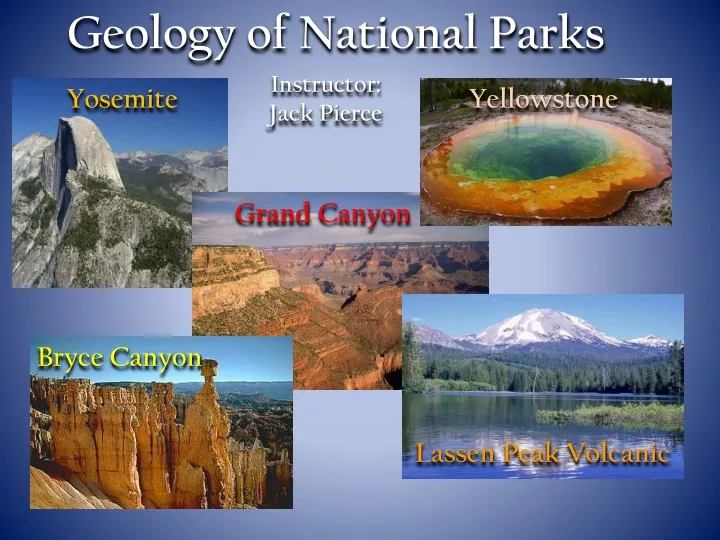
Explore the geological wonders of Yosemite, Yellowstone, Grand Canyon, and more in this class led by instructor Jack Pierce. Learn about rock types, plate tectonics, and the forces that shaped these iconic national parks.

E N D
Geology of National Parks Instructor: Jack Pierce Yosemite Yellowstone Grand Canyon Bryce Canyon LassenPeak Volcanic
Geology of National Parks Overview • “More than a Park Ranger Discussion of National Parks” • This class surveys basic geologic principles which include the • physical and historical geological characteristics of each • national park. • Hands-on examples of various rock types will be presented for • each national park. • Discussion will include various geological interest points within • each national park.
National Park Geologic Background • The Rock Cycle - Igneous, Sedimentary, Metamorphic Rocks • Plate Tectonic Overview • The Geologic Time Scale Geologic Time Scale The Rock Cycle Plate Tectonics
Pangaea Alfred Wegener • Alfred Wegener – German Meteorologist – geophysicist • Proposed that continents drift - observed Africa and South America (middle 1920’s) • Proposed the super-continent Pangaea • Found evidence to support his hypothesis of Continental Drift • fossil evidence, rock and climate correlations • Continental Drift hypothesis was NOT accepted --- Wegener the • laughing stalk of the science world • Could not answer HOW the continents move
Seafloor spreading Magma rises from the mantle “spreading apart” and creates new ocean floor – discovered in the 1960’s oldest ocean floor Youngest ocean floor oldest ocean floor Mantle Magma Mantle
The Theory of Plate Tectonics solid rigid lithospheric plates riding along a “plastic” (hot wax) material called the asthenosphere continental and ocean floor material lithosphere upper mantle Asthenosphere – hot mantle rock that behaves like “hot wax” lithosphere Asthenosphere
Continents Ride on Plates Plate Africa
3-Types of Plate Boundaries • plates move relative to one another • all major interactions of deformation occur at plate boundaries • most volcanic and EQ activities occur at plate boundaries • Divergent Boundary: • new ocean floor is produced (2-3 cm/yr) • ocean floor “grows” equally on both • sides of the ridge’ • Example: Mid-Atlantic Ridge Convergent Boundaries Ocean-Cont Ocean-Ocean Cont-Cont • Transform Boundary • plates slide past one another • common on the ocean floor • Example: San Andreas Fault
The Geologic Time Scale: • Created during the nineteenth century in Western • Europe and Great Britain • Sub-divides the 4.6 billion-year history of the earth • Eons • Eras • Periods • Epochs Larger Time Frame Smaller Time Frame
Age of Reptiles Amphibians Age of fish Invertebrates
Yosemite National Park Established in 1890
California Yosemite National Park Yosemite Valley
Intrusive Igneous Rocks of Yosemite • Magma cools below the surface • Magma cools slowly • Visible mineral grains • quartz, orthoclase, plagioclase, hornblende, • biotite • Various forms of granite • granodiorite, tonalite, quartz-monzonite K, Al, Na, Ca, SiO2 NEVER TAKE GRANITE FOR GRANITE ! Diorite Gabbro increasing Fe, Mg decreasing SiO2
How did the granite form to produce Yosemite? The Yosemite Tectonic Setting Ocean to Continent Convergence A A. convergence of plates D B. subduction of oceanic plate material C. oceanic plate melts and less dense magma rises B C Yosemite Granite D. formation of composite volcanoes (explosive) on the continent
El Capitan Monolith Cathedral Rocks granite Half Dome Quartz Monzonite granite
The land continued to push up, the water continued to erode down. The V-shaped valley got deeper. The mountains were pushed up higher from an increase in activity below the earth’s surface, causing the Merced river to dig deeper (erode) into its valley. 25-2 m.y. Uplift and erosion stripped away most of the sedimentary layers, leaving the cooled magma (granite) exposed. 80-25 m.y. 220-80 m.y. Layered sediments covered the sea floor west of the North American continent. 470-220 m.y.
The sediment eventually filled Lake Yosemite and turned it into the meadows and forests of today. Today The glaciers melted out of Yosemite Valley. 10,000 yrs An ice age occurred. Glaciers from the highest parts of the Sierra Nevada grew so big that they flowed down through Yosemite Valley, widening and cutting the Merced river’s path. 2 m.y.
Geologic Forces that Shaped Present Day Yosemite National Park • Glacial Processes • Strong erosive glacial forces produce the striking topography • observed today throughout Yosemite Valley • Weathering and Mass Wasting Processes • Physical / Chemical processes work 24/7 to reduce • topography of the Yosemite Valley • Mass wasting processes involve the down-slope movement • of weathered material under the influence of gravity
Glacial Processes Alpine (valley) glaciation Continental glaciation • Exists in high mountainous areas • Occupies pre-existing river valleys • Typically bounded by steep • mountain walls • Typically, lengths are longer than • width • Extensively covers continents • Greenland, Antarctica • Flat broad large ice sheets Great Lakes U.S. Yosemite
Evidence of past glacial activity in Yosemite – What do glaciers leave behind? River valleys before glaciation (note the “V” shape valleys) Glaciation takes place and invades the “V” shape valleys Glacial Erosion – the forces of glacial activity Erosional features left after glaciation creating various erosion features U-shaped valley horns cirques areates glacial moraines hanging valleys
Glacial Erosion – Glacial landforms from erosion Plucking processes Ice body moves across bedrock fracturing rock material. Frost wedging processes migrate through cracks and rock material is plucked out on the low pressure side. Frost wedging Abrasion processes Rock material embedded within the glacier moves along the surface and scratches, scours and produces grooves and striations Acts like sandpaper and “polishes” the rock surface.
Can you see the U-shaped valley? Can you see the hanging valley? Yosemite
Yosemite Region Yosemite Valley
Glacial moraines: Layers of “rock debris” (piles of rock) left over from an advancing / retreating glacier Tuolumne Meadows (lateral moraine) Base of Half Dome (medial moraine) Beginning of Yosemite Valley – terminal moraine
Erosional features (landforms) of Alpine glaciation Roches Moutonnees elongated hills that appear to be asymmetrical bedrock knobs that protrude upwards from the bedrock Direction of glacier plucking Glacier moves over resistant bedrock producing a gentle slope and plucking of debris steepens the opposite side Direction of glacier plucking
Lembert Dome - Yosemite flow direction of glacier
How did this boulder get here? • Erratic • “huge” rock fragments “floating” in the moving glacier • glacier melts and literally drops • and the boulder settles to • the ground.
Weathering Processes at Yosemite Rocks can be broken down or chemically altered on the earth’s surface. Mechanical Weathering: Rocks are physically broken down by various surface processes into smaller parts without changing physical properties. Chemical Weathering: Rocks are altered from one form to a completely new form with a different set of physical properties.
Yosemite Weathering Frost Wedging • Repeated cycles of freezing • and thawing. • Ice expands 9% of its volume. • Rock is continually broken • down over geologic time • Part of the Yosemite • weathering cycle.
Frost Wedging – rocks are broken into plates and split apart.
Exfoliation • unloading of overlying rock • material releases pressure • expansion of granitic bodies • causing “sheeting” or slabbing • granite • granite “sheets” break along • planes of weakness or joints • exacerbated by frost wedging • dominant weathering force • in Yosemite
Exfoliation Dome – granite is “sheeting” from loss of pressure due to unloading processes.
Exfoliation at Half Dome Royal Arches - Exfoliation Yosemite Exfoliation
Lembert Dome Tunnel to view the U-shaped Valley