Download
1 / 28
280 likes | 379 Views
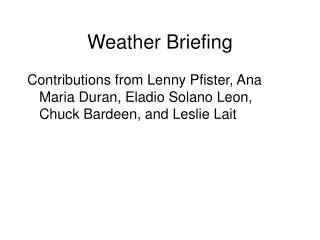
Weather Briefing Tuesday, April 18, 2006. INTEX-B Forecasts looking out to Wed-Sat (Apr 19-22). Prepared by Jennie Moody (UVA) and Mike Porter (FSU). A. B. A. B. 500mb Height Field (NOGAPS model) overlaid on VIS/IR Image.

E N D
Weather BriefingTuesday, April 18, 2006 INTEX-B Forecasts looking out to Wed-Sat (Apr 19-22) Prepared by Jennie Moody (UVA) and Mike Porter (FSU)
A B
A B
Current frontal boundaries at the surface associated with Low Center A
Current Upper Troposphere Specific Humidity Sat Image showing 1)the frontal boundary of Low A, and 2)the advancing WCB from Low B
Upper Troposphere Specific Humidity forecast for Tuesday (5PM Seattle, 2PM Hawaii) showing the upper level extension of Cyclones A and B A B
Upper Troposphere Specific Humidity forecast for Wednesday (5PM Seattle, 2PM Hawaii) showing the upper level extension of Cyclones A and B, and new system C B A C
Mixing Diagnostic For Wed afternoon (near time of Aura Overpass) Well-mixed air in UT on both sides of front
Aura Track Wednesday, cross section along this overpass in next slide (sample product) PV (Blue to red, 1PVU bright blue), Surface Pressure (yellow), 300mb wind barbs (kts), Boundary Layer Theta ( green lines, K)
Tuesday afternoon (5PM Seattle, 3PM Hawaii) location of front:
Wednesday afternoon (5PM Seattle, 3PM Hawaii) location of front:
GFS 500 hPa Vorticity 18 Z WED 18 Z TUES 18 Z FRI 18 Z THUR
GFS 300 hPa Winds 18 Z WED 18 Z TUES 18 Z FRI 18 Z THUR
Thursday,18 z Trof Offshore Potentially Lofting WCB carrying Asian Influence on the coast 500 hPa Winds & Vorticity 300 hPa Winds 700 hPa Winds & RH
Friday, 18 z Trof along West Coast, Little evidence of wraparound circulation Transition to Zonal flow offshore 500 hPa Winds & Vorticity 300 hPa Winds 700 hPa Winds & RH
Seattle Local NATIONAL WEATHER SERVICE SEATTLE WA925 AM PDT TUE APR 18 2006.SYNOPSIS...A WEAK UPPER LEVEL RIDGE OVER WESTERN WASHINGTON TODAY WILL KEEP AN APPROACHING FRONT OFF THE COAST. THE RIDGE WILL SHIFT GRADUALLY EAST THROUGH WEDNESDAY ALLOWING THE SLOWLY APPROACHING FRONT TO BRING A CHANCE OF RAIN TO THE COAST. THE FRONT WILL MOVE INLAND LATE THURSDAY WITH THE TRAILING UPPER LEVEL TROUGH FOLLOWING ON FRIDAY. ANOTHER UPPER LEVEL RIDGE WILL BUILD OVER THE AREA THIS WEEKEND.
04-18-06 Contribution from STEM 3km 3km 5.4km
04-19-06 Plume to North brought South to more accessible latitudes 3km 3km 5.4km
04-20-06 Some interesting offshore gradients are accessible to SW. 3km 3km 5.4km
04-21-06 Feature continues, with higher concentrations in upper altitude. 3km 3km 5.4km
Time series on 134.95 W, 46.08N Pollution comes in at upper level with most intensity on April 21 at mid troposphere.
Contrast to biomass burning Biomass burning and anthropogenic plumes aren’t located in same place.