Download

1 / 25
250 likes | 259 Views
Explore the evolution of GIS architecture and the integration of geospatial systems into key business applications, moving from desktop to web-based platforms and leveraging web services. Learn about different GIS configurations and building blocks of cloud architecture.

E N D
Geospatial Systems Architecture Todd Bacastow
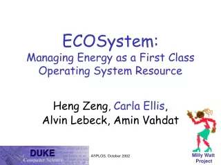
GIS Evolution http://wiki.gis.com/wiki/images/8/81/FallSDS11Fig2-1_Evolution.jpg
GIS Users Number of Users Internet Viewer Component Hand-held Desktop Professional Functionality
Market Forces • Integrating spatial data analysis and map visualization into key business applications • Moving and consolidating spatial data • Moving client/server mapping applications to the web and looking to web services
What is an architecture? • There is no universally agreed definition • A system architecture defines the structure and/or behavior of a system • Best be thought of as a representation • It is also a process because a sequence of steps • It can also be a discipline
Analogies • Consider a community that maintains an infrastructure for a public service to homes and businesses. This infrastructure might include: • Electricity producers • Drinking water purification and distribution • Sewage treatment • Other waste disposal • Natural gas distribution • Public transport • Cable television and telephones • Roads and toll ways
Evolution • business processes • systems structure • technical framework • product technologies
Evolution business processes + systems structure + technical framework + product technologies
GIS Configuration Alternative:Stand alone business processes + systems structure + technical framework + product technologies
GIS Configuration Alternative:Connected Desktop business processes + systems structure + technical framework + product technologies
GIS Configuration Alternative:Centralized Configuration Alternative business processes + systems structure + technical framework + product technologies
GIS Configuration Alternative:Centralized Configuration Alternative business processes + systems structure + technical framework + product technologies
GIS Configuration Alternative:Federated business processes + systems structure + technical framework + product technologies
GIS Configuration Alternative:Mobile business processes + systems structure + technical framework + product technologies
Internet/Web Applications Browsers Web Web Server Broker Databases business processes + systems structure + technical framework + product technologies
GIS Portal GIS Portal GIS Portal Cloud Architecture Building Blocks • Network architecture (Distributed) • Loosely Coupled • Internet Standards • Many GeoServices • Many Clients • Metadata Servers • Open / Interoperable • Full GIS capabilities GIS Users Connect and UseCheckout and Use Search Catalog and Find World Wide Web • Publish GIS Data & Services • Document in Catalog Metadata Server Author, Manage, Serve Catalogs Author, Manage, Serve Geographic Information Collections business processes + systems structure + technical framework + product technologies
How? • Consume and expose Web services for: • Mapping • Metadata • Data sharing and distribution • Geoprocessing • Provide standard services and components for web developer (.Net, “generic XML/SOAP”, or Java API’s)
GIS Services Enterprise Applications Browsers Web Broker Web Server Services Databases business processes + systems structure + technical framework + product technologies
Integration business processes + systems structure + technical framework + product technologies
Another view of architecture • Enterprise • Information • Computational • Engineering • Technology
System Architecture • ISO Reference Model of Open Distributed Processing (RM-ODP) • Enterprise Viewpoint: • It is directed to the needs of the users of an information system. • Information Viewpoint: • It focuses on the information content of the enterprise. • Computational Viewpoint: • It deals with the logical partitioning of the distributed applications independent of any specific distributed environment on which they run. • Engineering Viewpoint: • It addresses the issues of system support (platform) for distributed applications. • Technology Viewpoint: • The technology model identifies possible technical artifacts for the engineering mechanisms, computational structures, information structures, and enterprise structures.
. Architecture Development
Steps • Defining Architecture Requirements. • to enable the system to meet the community’s goals and objectives. • Defining a Candidate Architectures. • to evolve an architecture gradually. • Defining Enterprise Architecture. • integrate it into an enterprise architecture model. • Defining Reference Architecture. • a working example designed and proven for use in by the participants • Validating a Reference Architecture.
Readings • GIS software architectures • http://wiki.gis.com/wiki/index.php/GIS_Software_Technology • ESRI GIS products • http://wiki.gis.com/wiki/index.php/GIS_Product_Architecture