Download
1 / 60
620 likes | 835 Views
CRWR. Introduction to GIS in Water Resources. David R. Maidment Director, Center for Research in Water Resources University of Texas at Austin. National Hydro Data Programs. National Elevation Dataset (NED). National Hydrography Dataset (NHD). NED-Hydrology .

E N D
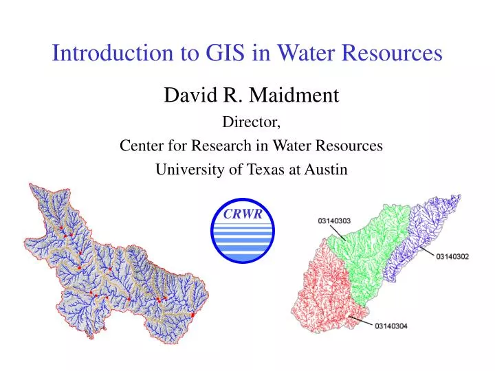
CRWR Introduction to GIS in Water Resources David R. Maidment Director, Center for Research in Water Resources University of Texas at Austin
National Hydro Data Programs National Elevation Dataset (NED) National Hydrography Dataset (NHD) NED-Hydrology Watershed Boundary Dataset
Digital Elevation Model with 1 arc-second (30m) cells Seamless in 1° blocks for the United States 10 billion data Derived from USGS 1:24,000 quadrangle sheets National Elevation Dataset
Digital Elevation Model (DEM) 720 720 Contours 740 720 700 680 740 720 700 680
32 64 128 16 1 8 4 2 Eight Direction Pour Point Model Water flows in the direction of steepest descent
32 64 128 16 1 8 4 2 Flow Direction Grid
Stream cell Cell to Cell Grid Network Through the Landscape
National Hydro Data Programs National Elevation Dataset (NED) National Hydrography Dataset (NHD) NED-Hydrology Watershed Boundary Dataset
Watersheds of the US 8-digit HUC watersheds 2-digit water resource regions
Hydrologic Unit Code Watersheds ~ 2000 for US, about the size of counties
Watershed Hierarchy Digit # 2 4 6 8 HUC 10 12 NED-H Available In Progress
National Program by USGS and USDA (NRCS) Boundaries for 10- and 12- digit watersheds First cut is by automated delineation from NED Hand checked and edited Watershed Boundary Dataset 10-digit watersheds
National program by USGS and NWS 5000 cellthreshold on a 30m DEM (~ 8 km2 average drainage area) ~ 1 million catchments for US when completed Includes grid derived products e.g. topmodel index
River networks for 8-digit HUC watersheds
Lower West Fork, Trinity River Basin HUC = 12030102
NHD River Reaches 412 River Reaches In Upper West Fork
River Reach Codes Rch_Code = 12030102000151 Rch_Code = 12030102000005 Segment# HUC#
Colorado River Network 1:100,000 scale river network developed from NHD ~ 60,000 edges 40,000 mile2 drainage area
City of Austin Stream Network Developed from 1”=100’ Capco Areal photogrammetry 1:1200 scale 63,000 edges 6,300 stream miles
Stream Definition: Waller Creek Austin Watersheds with Streamsderived from Aerial Photographs Streamlines generated by the aerial photographs are not always continuous.
Information for Correcting Stream Network • DEM • Contours • Storm sewers • Orthophotos
Resulting Corrected Stream • Subsequent steps: • Verification of corrected streams by flood hydrologists. • Running “tracer” program to connect arcs. • Burning of streams into DEM.
Colorado River at Mansfield Dam From NHD 1:100,000 scale River Reaches Lake Travis City of Austin Stream network 1:1200 scale
Detailed Comparison between NHD and Austin streams Good agreement between data sets developed independently at very different spatial scales
County Level Digital Soil Maps
National Water Information System Web access to USGS water resources data in real time
Synthesis of GIS and Modeling (slide from 1st International Conference on GIS and Environmental Modeling, Boulder, 1991) GIS Environmental Modeling Environmental description Process representation Input Data Model Results
1 Models 2 Model 1 Data base Model 2 Data sources Form the model within the frame of the available data Data-Driven Modeling (slide from 3rd International Conference on GIS and Environmental Modeling, Santa Fe, 1996)
Successes in GIS-Model Integration • EPA Office of Science and Technology • BASINS • Hydrologic Engineering Center • HEC GeoRAS and HEC-GeoHMS • Waterways Experiment Station and Brigham Young University • WMS, GMS, SMS,… • Danish Hydraulic Institute • Mike11 GIS, Mike Basin, Mike21 GIS
BASINS - Integrating GIS and Water Quality Modeling Data Cartographic Monitoring Loadings Tools Target Assessment Data Mining Reporting • Models • HSPF - NPSM • QUAL2E • TOXIROUTE • Post-Processors Target Assess DM Decisions Watershed Management . TMDL . Source Water Protection . Stormwater State and Local Data
ArcView Digital Elevation Model ArcView Flood plain maps HEC-RAS Water surface profiles HEC-HMS Flood discharge Integrating GIS and HEC Flood Models HEC-GeoHMS HEC-GeoRAS Digital Map Database
ArcView Digital Elevation Model ArcView Flood plain maps HEC-RAS Water surface profiles HEC-HMS Flood discharge Integrating GIS and HEC Flood Models HEC-GeoHMS HEC-GeoRAS Digital Map Database
Selected Watersheds and Streams Mansfield Dam Colorado River
HMS Schematic Prepared with CRWR-PrePro Mansfield Dam Colorado River