Download
1 / 31
310 likes | 542 Views
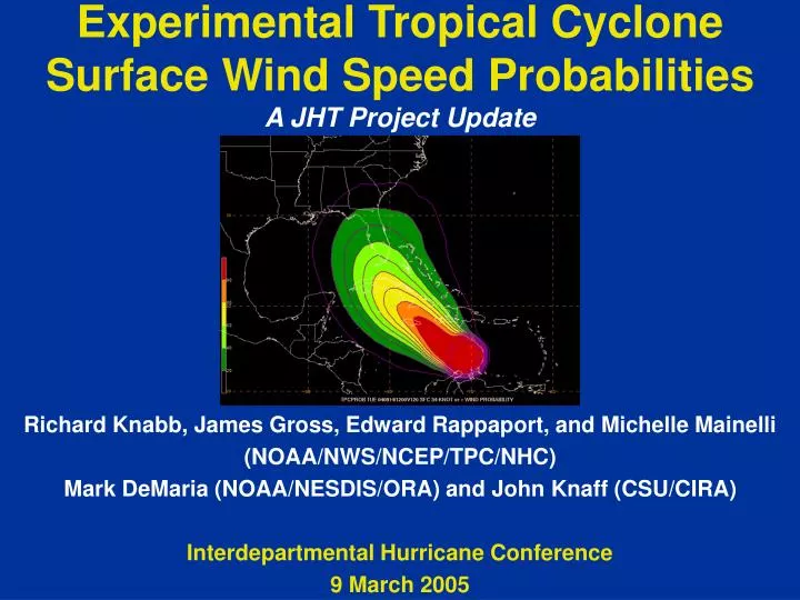
Experimental Tropical Cyclone Surface Wind Speed Probabilities A JHT Project Update. Richard Knabb, James Gross, Edward Rappaport, and Michelle Mainelli (NOAA/NWS/NCEP/TPC/NHC) Mark DeMaria (NOAA/NESDIS/ORA) and John Knaff (CSU/CIRA) Interdepartmental Hurricane Conference 9 March 2005.

E N D
Experimental Tropical Cyclone Surface Wind Speed ProbabilitiesA JHT Project Update Richard Knabb, James Gross, Edward Rappaport, and Michelle Mainelli (NOAA/NWS/NCEP/TPC/NHC) Mark DeMaria (NOAA/NESDIS/ORA) and John Knaff (CSU/CIRA) Interdepartmental Hurricane Conference 9 March 2005
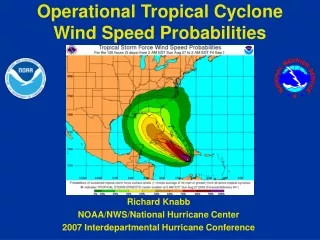
Current TPC/NHC Products Used to Convey Uncertainty Strike Probability Graphic
Current TPC/NHC Products Used to Convey Uncertainty Strike Probability Text Product (SPF)
Current TPC/NHC Products Used to Convey Uncertainty Watch/Warning Graphic
Why Consider Wind Speed Probabilities? • Need for improved means of conveying forecast uncertainty to various user communities • Current products do not account for combined uncertainty in track, intensity, and size • Current strike probabilities only extend three days into forecast period • The chances of wind speeds exceeding particular thresholds (e.g., tropical storm force, hurricane force) have more direct meaning and impact • Potential to provide users with information that enhances their ability to make preparedness decisions specific to their own situations
Computing Wind Speed Probabilities • Current DeMaria, Knaff, et al. JHT project • Use of Monte Carlo Probability (MCP) model • Create large set of plausible tracks and intensities (realizations), centered around current official forecast, determined by random sampling of historical track and intensity errors in official forecasts • Climatology and persistence (CLIPER) model used to create perturbations in wind radii along each track realization • Climatology based on past operational radii estimates • Radii adjustment (maximum to average extent) expected to slightly reduce probabilities, esp. in first 1-2 days of forecast, and be more representative of probability of actual wind speeds • Probabilities computed by counting the number of times each 2D grid point falls within a particular wind speed radius relative to the number of realizations
Computing Wind Speed Probabilities • Computed each forecast cycle for all active tropical cyclones in the Atlantic, eastern/central Pacific, and western Pacific basins • Computed on 2-D grids with 0.5-degree lat/lon spacing • Provides probabilities of the surface wind speed equal to or exceeding 34, 50, and 64 kt over specified time intervals (0-120 hours in 12-hour intervals) • Individual interval or cumulative probabilities • Gridded, graphical, and text products can be produced
Hurricane Watch issued 52 h before landfall @ 2 am CDT Thu Sep 16
34 kt Cumulative 0-120 h 12 hourly 00 UTC Tue 14 Sep Gridded probabilities viewed in NAWIPS at TPC
34 kt Cumulative 0-120 h 00 UTC Tue 14 Sep 73% or3 in 4
64 kt Cumulative 0-120 h 12 hourly 00 UTC Tue 14 Sep
64 kt Cumulative 0-120 h 00 UTC Tue 14 Sep 24%or1 in 4 Hurricane Watch Issued (120 h probability range 5 to 30%)
64 kt Cumulative 0-120 h 18 UTC Thu 12 Aug Intensity 90 kt R64 25 20 10 20 Hurricane Charley (2004)
Experimental GriddedProducts for WFOs • Experimental wind speed probability grids to be available in AWIPS in September 2005 • AWIPS grid domain 231 covering entire Northern Hemisphere • Will be disseminated no earlier than ~15 minutes after TCM issuance deadline, since all TC advisories must be out to be included in single gridded product • Additional products for special advisories (infrequent) • Cumulative probabilities, 0-120 hours at 12-h intervals • Separate fields for probabilities of >= 34, 50, and 64 kt • 0.5 degree lat/lon grid spacing • Can provide input to experimental WFO text and graphical products • Eventually will also go straight into NDFD
Experimental TPC Website Probability Graphics • Experimental, animated graphical wind speed probabilities planned on TPC website for 2005 season • Atlantic and eastern Pacific basins only • Content under development • Separate 0-120 h animations of cumulative probabilities for each TC, for each wind speed threshold (34, 50, and 64 kt) • One 120 h still frame for each full basin, for each speed threshold • Possible operational implementation in 2006 • Potential replacement for existing strike probability graphics
Experimental TPC Website Probability Graphics 34 kt example
Experimental TPC Website Probability Graphics 50 kt example
Experimental TPC Website Probability Graphics 64 kt example
Experimental Wind Speed Probability Text Products • Provide both individual period (12-hourly) and cumulative probabilities in the same single product • Also provide probabilities for three wind speed thresholds (34, 50, 64 kt) in that same single product • 15 separate products/headers required • 3 basins (Atlantic, eastern Pacific, central Pacific) • 5 TCs/bins in each basin • Experimental generation in 2005, possibly operational in 2006 • Potential replacement for existing strike probability text product
Experimental Wind Speed Probability Text Product (top portion)
The WSP would replace the SPF, and be issued with each individual TC advisory package
All three wind speed thresholds included in this single product (Thresholds in all units for WMO RA-IV areas)
Output intervals are 12 hourly to 48 hours, then 24 hourly to 120 hours
Each row of values corresponds to one wind speed threshold at one location
Incremental interval and cumulative (in parentheses) probability values in percent “X” denotes less than 1% Described in legend at end of product (not shown)
Data for a particular location and speed only shown when 120 hour cumulative probability is at least 3%
Farther down in same product, many locations show higher probabilities and for all three speed thresholds Separate row of probabilities for each wind speed threshold at each location
Challenges and Ongoing Work • Significant training, outreach, and feedback required • Helping different types of users interpret the output and assess their risk • Small probabilities of an extreme event are significant • Use of cumulative vs. individual period probabilities • Perceived appearance of “growing storm” in graphical animations • Potential use in WFO text and graphical products • Improving efficiency of MCP code and graphical post-processing • Verification • Objective guidance for watch/warning breakpoints? • MCP probabilities for TCs are zero in many locations that could experience 34 kt winds or greater due to other weather systems…how to eventually merge with other probabilistic output?