Download
1 / 33
330 likes | 337 Views
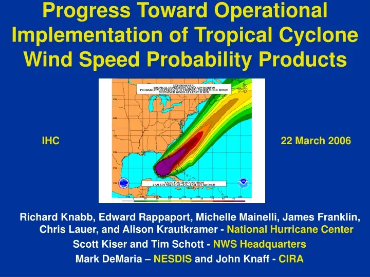
Progress Toward Operational Implementation of Tropical Cyclone Wind Speed Probability Products. IHC. 22 March 2006. Richard Knabb, Edward Rappaport, Michelle Mainelli, James Franklin, Chris Lauer, and Alison Krautkramer - National Hurricane Center

E N D
Progress Toward Operational Implementation of Tropical Cyclone Wind Speed Probability Products IHC 22 March 2006 Richard Knabb, Edward Rappaport, Michelle Mainelli, James Franklin, Chris Lauer, and Alison Krautkramer - National Hurricane Center Scott Kiser and Tim Schott - NWS Headquarters Mark DeMaria – NESDIS and John Knaff - CIRA
Existing TPC/NHC Products Used to Convey Uncertainty Watch/Warning GraphicIndicates forecast track and long-term mean error
Existing TPC/NHC Products Used to Convey Uncertainty Strike Probability GraphicIndicates chances of a “close approach” of the center
Existing TPC/NHC Products Used to Convey Uncertainty Strike Probability Text Product
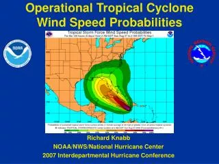
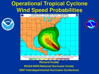
Why a new probability product? Need for improved means of conveying tropical cyclone forecast uncertainty to various types of users • New product is about a weather event at any specific location • Conveys chances of wind speeds of at least particular thresholds • 34 kt (tropical storm force) • 50 kt • 64 kt (hurricane force) • Accounts for combined uncertainty in track, intensity, and size • Extends to 5 days • Includes inland locations • Will replace strike probabilities in 2006
What are the new wind speed probability products? • Text product (one per storm) • Atlantic (NHC) • Eastern Pacific (NHC) • Central Pacific (CPHC) • Website graphics (basin-wide and storm-centered) • Atlantic (NHC) • Eastern Pacific (NHC) • Central Pacific (CPHC) • Western Pacific (CPHC)
What do the new probability products tell you? Answers to three main questions: • What are the chances this event is going to happen to me? • Do I need to prepare? • Cumulative period probabilities • New graphics and text products from NHC and CPHC • When is the event most likely to start at my location? • How much time do I have left to prepare? • Individual period probabilities • New text products from NHC and CPHC • What are the chances this event will be happening to me on a particular day (or part of a day)? • How long will the storm last? Will the weather be bad on Saturday? • Incremental probabilities • Potential future products from local NWS Forecast Offices
NHC Website Probability Graphics 34 kt example
NHC Website Probability Graphics 34 kt example
NHC Website Probability Graphics 50 kt example
NHC Website Probability Graphics 50 kt example
NHC Website Probability Graphics 64 kt example
NHC Website Probability Graphics 64 kt example
Example Interpretation of Output What is the chance that winds of tropical storm force (34 kt or greater) will occur at Charlotte NC during the next five days? 34 kt probabilities at Charlotte NC
Example Interpretation of Output What is the chance that winds of tropical storm force (34 kt or greater) will occur at Charlotte NC during the next five days? 42% 34 kt probabilities at Charlotte NC
Example Interpretation of Output What is the chance that winds of tropical storm force (34 kt or greater) will occur at Charlotte NC during the next five days? 42% When are these winds most likely to start? 34 kt probabilities at Charlotte NC
Example Interpretation of Output What is the chance that winds of tropical storm force (34 kt or greater) will occur at Charlotte NC during the next five days? 42% When are these winds most likely to start? From 18Z Sun to 18Z Mon (18% chance) 34 kt probabilities at Charlotte NC
Exact track forecast goes over Galveston, but there is also a significant chance of hurricane force winds farther east where actual landfall occurred.
Challenges and Ongoing Work • Significant training and outreach needed • Lessen the focus on exact track forecast • Do users understand probabilities? • “Small” probabilities • Enhancements to graphical products • Faster creation of grids and graphics created from them • Potential use by NWS forecast offices in their products • Verification • Objective guidance for watch/warning breakpoints • Gridded products for NDFD
Wind Speed Probability Methodology • Create large set of plausible tracks and intensities (ensemble members) roughly centered around the current official forecast • Determined by random sampling of historical track and intensity errors in official forecasts (since 2001) • Intensities consider whether a particular ensemble member is over land or water
Wind Speed Probability Methodology • The size of the tropical cyclone (set of wind radii) for each ensemble member is determined by a climatology and persistence (CLIPER) model and its error components • CLIPER models provide: • A baseline forecast for evaluating the skill of other models and forecasts • Basic guidance to use in making forecast for current storm • A general idea of how difficult a forecast was (based on CLIPER errors) • Wind radii CLIPER combines: • Recent trends and persistence in initial wind radii of the current storm • Climatological radii (based on operational estimates in several past storms) that vary with the storm’s initial and forecast location, forward speed, and intensity. In general: • Storms get larger in middle latitudes • Stronger storms have larger wind radii • Faster storms have larger wind radii to the right of direction of motion • For wind radii CLIPER, persistence dominates through about 36 h of the forecast, then climatology dominates
Wind Speed Probability Methodology • Operational wind radii definition: • Maximum extent of a particular wind speed somewhere in a quadrant of the storm • Creating wind swaths from these radii can overestimate area affected by that wind speed • For wind speed probabilities, adjustment is made so that the wind radii represent the average (not maximum) extent of winds in each quadrant • This adjustment makes wind speed probabilities more realistic for describing what might actually happen at any location
Wind Speed Probability Methodology • Swaths of particular wind speeds are then computed for each ensemble member. • Probabilities are computed on a lat-lon grid (0.5 degree) by counting the fraction of ensemble members in which each grid point falls within a swath of each wind speed.
Wind Speed Probability Methodology • Computed and output on a single Northern Hemispheric grid • Done after each forecast cycle for all active tropical cyclones in the following basins: • Atlantic (includes Caribbean and Gulf of Mexico) • Eastern Pacific • Central Pacific • Western Pacific • Can be converted to graphics and text Example of 0-120 hour cumulative probabilities of 34 kt winds
34-KT WIND RADII FORECAST VERIFICATION: “DRCL” IS A CLIPER MODEL
64 kt Cumulative 0-120 h 18 UTC Thu 12 Aug Note that chances of hurricane conditions at Tampa Bay and Port Charlotte are both around 30%! Hurricane Charley (2004)