Download
1 / 39
390 likes | 592 Views
GEO, GEONETCast and building a low cost ground receiving station. Ben Maathuis & Chris Mannaerts Dept Water Resources ITC- Enschede , The Netherlands. Layout of presentation. Group on Earth Observation (GEO) Global EO System of Systems EUMETSAT’s contribution to GEO: EUMETCast

E N D
GEO, GEONETCastand buildinga low cost ground receiving station Ben Maathuis & Chris Mannaerts Dept Water Resources ITC-Enschede, The Netherlands
Layout of presentation • Group on Earth Observation (GEO) • Global EO System of Systems • EUMETSAT’s contribution to GEO: EUMETCast • Services and data broadcasted • Ground reception system components • Data Management • Concluding remarks
GEO: the Group on Earth Observations An Intergovernmental Organization with 89 Member Countries, the European Commission and around 67 Participating Organizations U.S. Department of State, Washington DC July 31, 2003
GEO objectives • Improve and coordinate earth (land & ocean) observation systems • Provide easier and more open data access • Foster use (science, applications) also through capacity building … to answer Society’s need for informed decision making GOAL of GEO: GEOSS:A Global, Coordinated, Comprehensive and Sustained System of Observing Systems
GEO open data access & sharing principles • Open Access & exchange of data (globally) from Airborne, Space based and In Situ Observation Systems • Data and Products at Minimum Time delay and Minimum Cost • Free of Charge or cost of reproduction for Research and Education
GEONETCast provides free near real-time environmental and Earth observation data and derived products to a worldwide user community using a telecommunication satellite based data distribution system. GEONETCast as backbone for data provision
Layout of the GEONETCast telecommunication satellite based data distribution system GEONETCast – system layout
Near real-time satellite image reception using a communication satellite based data distribution system, example MSG GEONETCast - Africa
GEONETCast - Africa After central ground processing at EUMETSAT, images in full resolution are transmitted in HRIT mode, within five minutes of observation…. Euro Bird Atlantic Bird-EUTELSAT The data is re-transmitted to AB-EUTESAT via the Fucino ground station in Italy for C-Band reception for African Users Before the signal is received at a local ground receiving station it has traveled from MSG -> Darmstadt -> Usingen -> Eurobird-> Fucino -> AB-EUTELSAT -> Local Station (approximate distance is 5 * 36.000 km!!)
EUMETSAT • Data and Services provided by EUMETSAT (The European Organisation for Exploitation of Meteorological Satellites): Meteosat, Metop & Jason • Goal: Maintain continuity and develop the operational meteorological and climate data services with adequate satellite and ground infrastructure, and associated user services http://www.eumetsat.int
EUMETSAT Ground Segment Member State Cooperating State EPS Ground Station, Svalbard EUMETCast LA Turnaround Uplink, Near Paris MSG & Jason-2 Ground Station and EUMETCast Uplink, Usingen EUMETSAT HQ, Mission Control Centre, Darmstadt Backup Ground Station, Cheia EUMETCast African Turnaround Reception Station, Madrid ASCAT Transponder 1, Ankara Province MTP Primary Ground Station and EUMETCast Turnaround Station, Fucino EPS Backup Control Centre, Madrid ASCAT Transponder 3, Yozgat Province ASCAT Transponder 2, Eskisehir Province Backup and Ranging Ground Station Maspalomas, Gran Canaria
EUMETSAT Ground Segment Meteosat Antenna Usingen, Germany Meteosat Antenna Fucino, Italy Metop Antenna Spitzbergen, Norway Jason Antenna Usingen, Germany
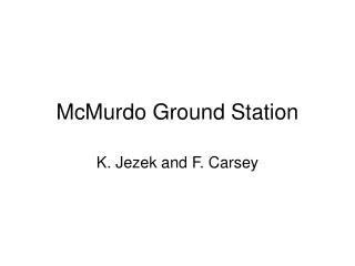
EUMETSAT Ground Segment • The Metop Global Data Service comprises orbit dumps from both Svalbard and McMurdo ground stations. • To improve data timeliness NASA’s McMurdo ground station in Antarctica is used to collect the data from the first half of the satellite’s orbit, in addition to the Svalbard ground station in the Arctic. • For orbits where Metop will perform a dump over McMurdo, the timeliness of products will be significantly improved over current service requirements. McMurdo Station, Ross Island (Antarctica)
EUMETSAT Control Centres MTP Control Centre MSG Control Centre EPS Control Centre
6 6 7 7 4 4 3 3 2 2 1 1 5 5 8 8 Satellite Application Facilities (SAFs) in Europe Member State Cooperating State Support to Nowcasting and Very Short Range Forecasting Ocean and Sea Ice Climate Monitoring Numerical Weather Prediction Land Surface Analysis Ozone and Atmospheric Chemistry Monitoring GRAS Meteorology Support to Operational Hydrology and Water Management SAF Consortium Member Additional Met Service Users
Data disseminated through GEONETCast • Space-based observations from the Meteosat, Metop, Jason-2, GOES, MT-SAT and FY2 satellites. At their most frequent, these data are delivered to users within five minutes of processing. • MODIS level 1 and 2 products covering selective geographical regions. • Numerical weather forecasts. • In-situ observational data. • Land application products covering Europe, Africa and South America. • Global and regional marine meteorological and ocean surface products. • Atmospheric chemistry products.
Data disseminated through GEONETCast • In addition, a wide range of third-party meteorological and environmental products are available on EUMETCast. The range includes: • Level 1 Satellite data (e.g. GOES-E & GOES-W, MTSAT, FY2D, aqua/terra MODIS) • Meteorological products • In-situ observational data • Numerical weather forecasts • Land application products covering Europe, Africa and South America • Global and regional marine meteorological and ocean surface products • A comprehensive list of all products available on EUMETCast can be found on the Product Navigator.
User Registration • Users interested in receiving products and services delivered via GEONETCast should register with a GEONETCast network provider covering their geographical location. To register for the service provided by EUMETCast (EUMETCast-Europe, EUMETCast-Africa, EUMETCast-America) complete the online registration form • https://eoportal.eumetsat.int
Atlantic Bird – EUTELSAT footprint & antenna size Atlantic Bird 3 – EUTELSAT5 is situated at 5 degree West. EUMETCast is available via one of the C-band transponders. Coverage map showing EIRP contours and corresponding antenna sizes for AB -EUTELSAT C-band dBW footprint
EUTELSAT 5 West A C-band transponder settings • http://www.eumetsat.int/website/home/Data/DataDelivery/EUMETCast/ReceptionStationSetup/index.html
Pointing your antenna http://www.dishpointer.com/
Ground receiving components • Satellite off-set or prime focus antenna, with: • universal V/H LNB in C-band • circular polarisationfeedhorn, • C-band LNB, bandpass filter recommended (in areas with radar interference)
Ground receiving components • Computer equipment needed • 2 x PC with minimum 2.0 GHz Pentium™ IV; 1Gb RAM, 36Gb internal disk (or more, depending on storage required); USB port for EKU; 5 volt PCI bus (compatible with recommended DVB PCI card); 100/10 base Ethernet card (if required). Microsoft Internet Explorer (web browser) version 5.5, or later version, or Mozilla, or similar, Web browser, including JAVA RTE, (required for display of the TELLICAST monitoring information). Two PCs are recommended - one for the DVB acquisition and a second for processing applications. • EUMETSAT recommends setting up the EUMETCast PC as a receiving station and ftp or file server only and not to install and run other application software on this PC. Peaks in disk and bus usage could interrupt DVB data reception.
Ground receiving components • Digital Video Broadcasting is the Digital Video Broadcasting Forward Error Correction (FEC) and demodulation standard for Satellite Television and dates from 1994, in its first release; • The telecommunications providers supply the DVB multicast distribution. Encoded data/product files are transferred via a dedicated communications line from EUMETSAT to the uplink facility where they are transmitted to a geostationary communications satellite for broadcast to user receiving stations. Each receiving station decodes the signal and recreates the user data/products according to a defined directory and file name structure. Reception of data channels via satellite transponder and not televisions channels
Ground receiving components • Digital Video Broadcasting Board • DVB PCI Card (5 volts) - the following brands have been tested by EUMETSAT: TechniSat™ SkyStar2; BroadLogic™ V@box 2030; Hauppage WINTV (only older Technotrend based cards), Pentamedia™ Pent@Value Card, Technotrend budget and premium cards. DVB USB boxes: • DVB USB 1.1 boxes (up to 6 mbit/s only): Technisat™ SkyStar2 USB; Hauppage USB • DVB USB 2.0 boxes (> 20 mbit/s): TechnoTrend TT-connect S-2400; Dexatek DK-5702 I-TEK Sphere DVB-S • DVB Routers (LAN connectivity): IPricot IPR-S500 or other models
Ground receiving components • Communication Software needed • EUMETCast Client Software - used in conjunction with a username/password to decrypt the DVB signal. EUMETSAT is the only supplier of this type of client software licence package. • USB EKU • EUMETCast Key Unit (EKU) - used in association with the EUMETCast Client Software to access certain data services. The EKU is a USB device that controls the access to the multicast to allow only those stations fitted with the EKU to receive the restricted service. EUMETSAT is the sole supplier of the EKU and included in the delivery package is the EKU Run-time-Environment, for both MS Windows and Linux systems.
Operational ground receiving station LNB - transponder settings, signal and data services New files arrived on local system Monitor active channels, data load and statistics
Operational ground receiving station Automated Data Management using the Data Manager Menu as result from text file
Multicast channels and PIDs Each service available on EUMETCast has been assigned a corresponding multicast channel and Packet Identifier (PID). In order to receive the service, the relevant PID must be added in the DVB Data Service software. Part of the PID table http://www.eumetsat.int/website/home/Data/DataDelivery/EUMETCast/ReceptionStationSetup/ChannelsandPIDs/index.html
User Notification of Service Status http://www.eumetsat.int/website/home/Data/ServiceStatus/index.html?l=en Also subscription is possible to the UNS
Low cost ground reception systems in Africa Some of the antenna configuration at various locations in Africa Satellite Dish installed at Makarere University, Kampala, Uganda Satellite Dish installed at CGIS-NUR, Butare, Rwanda Satellite Dish installed at RCMRD, Nairobi, Kenya Others in Tunisia, Ethiopia, Ivory Coast, Ghana, Zimbabwe and South Africa; number of requests pending.
Low cost ground reception systems Temporary setup at Africa-GIS conference in 2009
Ground receiving station used during “Open Days” “Experiment in het Bos” – September 2011
Ground reception infrastructure @ ITC Both Ku and C-Band reception @ ITC
GEONETCast at ITC Keywords: Not only GEONETCast Ku-reception over Europe; Also GEONETCast reception over Africa, SE Asia and Latin America (C-Band); New reception room developed to offer dedicated training on use of ground reception infrastructure hard -and software; Check new services and develop new routines for relevant data sets –operate also manufacturer license; Update “DataManager” configuration files for automated storage of (newly arrived) data in structured manner.
Concluding remarks Now low cost ground receiving station can be constructed, using off-the-shelf components; The free data contained in GNC is applicable for many applications related to land, ocean and atmosphere; The ITC/52N-communities can provide the necessary backstopping and will continue to develop relevant utilities for processing and analysis of the data streams.