Download
1 / 47
470 likes | 478 Views
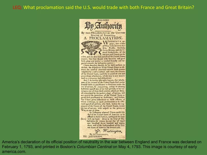
LEQ: What proclamation said the U.S. would trade with both France and Great Britain?.

E N D
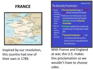
LEQ:What proclamation said the U.S. would trade with both France and Great Britain? America’s declaration of its official position of neutrality in the war between England and France was declared on February 1, 1793, and printed in Boston’s Columbian Centinal on May 4, 1793. This image is courtesy of early america.com.
LEQ:What proclamation said the U.S. would trade with both France and Great Britain?Proclamation of Neutrality America’s declaration of its official position of neutrality in the war between England and France was declared on February 1, 1793, and printed in Boston’s Columbian Centinal on May 4, 1793. This image is courtesy of early america.com.
Young America’s International Relations Basics This map shows the known world in 1790. The United States is shown in red. The British possessions in Canada are shown in purple. Green shows Spanish possessions. In blue is the Louisiana Territory, which at various times was possessed by France or by Spain. This image is courtesy of althistory.wikia.com.
Young America’s International RelationsVocabulary This image is from wordinfo.info.
A payment for protection. This image shows U.S. Navy Captain William Bainbridge paying tribute to the Dey of Algiers in 1800 (the U.S. Navy had been reorganized in 1798). This image is courtesy of Wikimedia Commons.
TributeA payment for protection. This image shows U.S. Navy Captain William Bainbridge paying tribute to the Dey of Algiers in 1800 (the U.S. Navy had been reorganized in 1798). This image is courtesy of Wikimedia Commons.
The United States paid tribute to the Barbary Coast States because they were stealing American ships, and imprisoning American sailors. In the Mediterranean Sea, United States traders faced pirates from the states of the Barbary Coast of North Africa– Morocco, Algeria, Tunisia, and Tripoli (now known as Libya). This image is courtesy of myholyoke.edu.
The act of choosing not to take sides in a dispute. President George Washington (seated on the right) sought the advice of his two chief cabinet officers, Thomas Jefferson, the Secretary of State (seated on the left), and Alexander Hamilton, the Secretary of the Treasury (standing). As they did on many other issues, Hamilton and Jefferson disagreed on a policy towards the new French Republic. This image is courtesy of alaynacsapushblog.blogspot.com.
NeutralThe act of choosing not to take sides in a dispute. President George Washington (seated on the right) sought the advice of his two chief cabinet officers, Thomas Jefferson, the Secretary of State (seated on the left), and Alexander Hamilton, the Secretary of the Treasury (standing). As they did on many other issues, Hamilton and Jefferson disagreed on a policy towards the new French Republic. This image is courtesy of alaynacsapushblog.blogspot.com.
President George Washington wanted the United States to stay neutral in the war between France and Great Britain and their allies. This painting shows the Battle of the Pyramids which was fought in July, 1798 in Egypt. At that time Egypt was allied with Great Britain. This image was created by Francois-Louis-Joseph Watteau (1758-1823). This image is courtesy of Wikimedia Commons.
The act of forcing people to serve military duty, especially sailors. Sailors were captured on American ships by the British, or in ports where American ships were stopped. This image is courtesy of contabile.org.uk.
ImpressmentThe act of forcing people to serve military duty, especially sailors. Sailors were captured on American ships by the British, or in ports where American ships were stopped. This image is courtesy of contabile.org.uk.
British ships not only stopped and seized American ships, they also impressed, or kidnapped, Americans sailors to serve in the British navy. This image is from the War of 1812. Between 1803 and 1812, the British impressed approximately 10,000 Americans to work on British ships. This image is courtesy of xtimeline.com.
Young America’s International Relations People to Meet This painting shows the Treaty of Greenville in which American Indian tribes ceded to the United States large parts of present-day Ohio, the future site of downtown Chicago, and the Fort Detroit area. This image is courtesy of americanindianhistory.blogspot.com.
The first President of the United States George Washington (1732-1799) never lived in Washington, D.C. while he was President of the United States. During his Presidency he lived in New York and Philadelphia. This painting was created by Gilbert Stuart (1755-1828) in 1797. The painting is courtesy of Wikimedia Commons.
George WashingtonThe first President of the United States George Washington (1732-1799) never lived in Washington, D.C. while he was President of the United States. During his Presidency he lived in New York and Philadelphia. This painting was created by Gilbert Stuart (1755-1828) in 1797. The painting is courtesy of Wikimedia Commons.
The First Vice President of the United States. John Adams (1735-1826) described the office of Vice President as “the most insignificant office that ever the invention of man contrived...” This painting was created by Asher Brown Durand (1767-1845) in 1728. This image is courtesy of Wikimedia Commons.
John AdamsThe First Vice President of the United States. John Adams (1735-1826) described the office of Vice President as “the most insignificant office that ever the invention of man contrived...” This painting was created by Asher Brown Durand (1767-1845) in 1728. This image is courtesy of Wikimedia Commons.
The First Secretary of State of the United States. Thomas Jefferson (1743-1826) resigned as Secretary of State in 1793. This painting was created by Charles Willson Peale (1741-1827) in 1791. This image is courtesy of Wikimedia Commons.
Thomas JeffersonThe First Secretary of State of the United States. Thomas Jefferson (1743-1826) resigned as Secretary of State in 1793. This painting was created by Charles Willson Peale (1741-1827) in 1791. This image is courtesy of Wikimedia Commons.
The First Secretary of the Treasury of the United States. Alexander Hamilton (1757-1804) was the architect of the financial system of the United States. This painting was created by John Trumbull (1756-1843) in 1806. This image is courtesy of Wikimedia Commons.
Alexander HamiltonThe First Secretary of the Treasury of the United States. Alexander Hamilton (1757-1804) was the architect of the financial system of the United States. This painting was created by John Trumbull (1756-1843) in 1806. This image is courtesy of Wikimedia Commons.
The First Chief Justice of the United States Supreme Court. John Jay (1745-1829) was, along with Alexander Hamilton and James Madison, one of the authors of The Federalist Papers.This painting was created by Gilbert Stuart (1755-1828) in 1794. The painting is courtesy of Wikimedia Commons.
John JayThe First Chief Justice of the United States Supreme Court. John Jay (1745-1829) was, along with Alexander Hamilton and James Madison, one of the authors of The Federalist Papers.This painting was created by Gilbert Stuart (1755-1828) in 1794. The painting is courtesy of Wikimedia Commons.
American diplomat whose agreement with Spain allowed American ships to use the lower Mississippi River and to trade through the port of New Orleans. Thomas Pinckney (1750-1828) was born in South Carolina, and was a veteran of the American Revolution and of the War of 1812. This painting was created by John Trumbull (1756-1843) circa 1800. The painting is courtesy of chicoraantiques.com.
Thomas PinckneyAmerican diplomat whose agreement with Spain allowed American ships to use the lower Mississippi River and to trade through the port of New Orleans. Thomas Pinckney (1750-1828) was born in South Carolina, and was a veteran of the American Revolution and of the War of 1812. This painting was created by John Trumbull (1756-1843) circa 1800. The painting is courtesy of chicoraantiques.com.
Young America’s International Relations Maps This map shows the known world in 1790. The United States is shown in red. The British possessions in Canada are shown in purple. Green shows Spanish possessions. In blue is the Louisiana Territory, which at various times was possessed by France or by Spain. This image is courtesy of althistory.wikia.com.
Land Belonging to the United States During the Federalist PeriodFind the Land Belonging to the United States during the Federalist Period on this map. This map shows the present boundaries of the states. The image is courtesy of imageck.com.
Land Belonging to the United States During the Federalist Period.Find the Land Belonging to the United States during the Federalist Period on this map. The land belonging to the United States during the Federalist Period is now highlighted in red. This image is courtesy of the University of Texas.
Appalachian MountainsFind the Appalachian Mountains on this map of the United States. This map shows the present boundaries of the states. The image is courtesy of imageck.com.
Appalachian MountainsFind the Appalachian Mountains on this map of the United States. This map shows the fine artwork of Mr. Housch in placing brown lines in the approximate area where the Appalachian Mountains are located. The image is courtesy of imageck.com.
Mississippi RiverFind the Mississippi River on this map of the United States. This map shows the present boundaries of the states. The image is courtesy of imageck.com.
Mississippi RiverFind the Mississippi River on this map of the United States. The Mississippi River is now highlighted in blue. The image is courtesy of imageck.com.
New OrleansFind New Orleans on this map of the 50 States of the United States. This image shows the 50 States of the United States. This image is courtesy of the University of Texas.
New OrleansFind New Orleans on this map of the 50 States of the United States. New Orleans is now marked with a red dot and the words “New Orleans.” This image shows the 50 States of the United States. This image is courtesy of the University of Texas.
Northwest TerritoryFind the Northwest Territory on this map of the 50 States of the United States. This image shows the 50 States of the United States. This image is courtesy of the University of Texas.
Northwest TerritoryFind the Northwest Territory on this map of the 50 States of the United States. The states of the Northwest Territory are now colored in red. Minnesota was part of Wisconsin during this time and part of the present state of Minnesota was in the Northwest Territory. This image shows the 50 States of the United States. This image is courtesy of the University of Texas.
Mediterranean SeaFind the Mediterranean Sea on this map of the world. This image is a political map of the world. This image is courtesy of the blankmap.org.
Mediterranean SeaFind the Mediterranean Sea on this map of the world. The Mediterranean Sea is now colored blue. This image is a political map of the world. This image is courtesy of blankmap.org.
Barbary Coast StatesFind the Barbary Coast States on this map of the world. This image is a political map of the world. This image is courtesy of blankmap.org.
Barbary Coast StatesFind the Barbary Coast States on this map of the world. The Barbary Coast States are now colored red. This image is a political map of the world. This image is courtesy of blankmap.org.
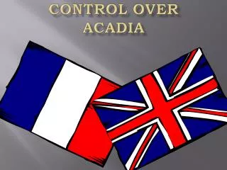
Great BritainFind Great Britain on this map of the world. This is a political map of the world. This image is courtesy of the blankmap.org.
Great BritainFind Great Britain on this map of the world. Great Britain is now colored red. This is a political map of the world. This image is courtesy of the blankmap.org.
FranceFind France on this map of the world. This is a political map of the world. This image is courtesy of the blankmap.org.
FranceFind France on this map of the world. France is now colored red. This is a political map of the world. This image is courtesy of the blankmap.org.
LEQ:What proclamation said the U.S. would trade with both France and Great Britain? America’s declaration of its official position of neutrality in the war between England and France was declared on February 1, 1793, and printed in Boston’s Columbian Centinal on May 4, 1793. This image is courtesy of early america.com.
LEQ:What proclamation said the U.S. would trade with both France and Great Britain?Proclamation of Neutrality America’s declaration of its official position of neutrality in the war between England and France was declared on February 1, 1793, and printed in Boston’s Columbian Centinal on May 4, 1793. This image is courtesy of early america.com.


![The Great War for Empire French and Indian War (1754-1763) [Seven Years’ War - Europe]](https://cdn1.slideserve.com/1758056/the-great-war-for-empire-french-and-indian-war-1754-1763-seven-years-war-europe-dt.jpg)